
Seend Cleeve
| Seend Cleeve | |
|---|---|
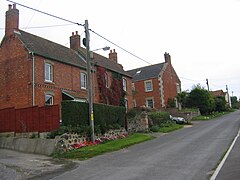 Main road of Seend Cleeve, with the village's only red telephone box visible in the background | |
 Seend Cleeve Location within Wiltshire | |
| OS grid reference | ST931610 |
| Civil parish | |
| Unitary authority | |
| Ceremonial county | |
| Region | |
| Country | England |
| Sovereign state | United Kingdom |
| Post town | Melksham |
| Postcode district | SN12 |
| Dialling code | 01380 |
| Police | Wiltshire |
| Fire | Dorset and Wiltshire |
| Ambulance | South Western |
| UK Parliament | |
| Website | Parish Council |
Seend Cleeve is a large hamlet or sub-village immediately west of Seend in Wiltshire, England. It lies about 2.3 miles (3.7 km) southeast of the town of Melksham.
A Primitive Methodist chapel and Sunday school were founded in Seend Cleeve.[1] In 1849, the chapel was rebuilt in red brick with ashlar quoins.[1] The chapel closed in 1979 and was converted into a private house in 2012.[1]
Seend Cleeve Quarry was a source of brown haematite. Since 1987 the quarry has been a Geological Site of Special Scientific Interest.
Seend Cleeve has two public houses: the Barge Inn[2] on the Kennet and Avon Canal, and the Brewery Inn.
References[]
- ^ a b c "Primitive Methodist Chapel, Seend Cleeve". Wiltshire Community History. Wiltshire Council. 2006. Retrieved 29 December 2010.
- ^ The Barge Inn
Further reading[]
- Pugh, R.B.; Crittall, Elizabeth (eds.); Chettle, H.F.; Powell, W.R.; Spalding, P.A.; Tillott, P.M. (1956). A History of the County of Wiltshire, Volume 7. Victoria County History. pp. 91–121.
{{cite book}}:|first2=has generic name (help)
External links[]
![]() Media related to Seend Cleeve at Wikimedia Commons
Media related to Seend Cleeve at Wikimedia Commons
Categories:
- Villages in Wiltshire