Selianitika
Selianitika
Σελιανίτικα | |
|---|---|
 Selianitika on a sunny day of winter | |
 Selianitika | |
| Coordinates: 38°16′N 22°1′E / 38.267°N 22.017°ECoordinates: 38°16′N 22°1′E / 38.267°N 22.017°E | |
| Country | Greece |
| Administrative region | Western Greece |
| Regional unit | Achaea |
| Municipality | Aigialeia |
| Municipal unit | Sympoliteia |
| Area | |
| • Rural | 2.8 km2 (1.1 sq mi) |
| Lowest elevation | 0 m (0 ft) |
| Population (2011)[1] | |
| • Rural | 902 |
| • Rural density | 320/km2 (830/sq mi) |
| Time zone | UTC+2 (EET) |
| • Summer (DST) | UTC+3 (EEST) |
| Postal code | 25 100 |
| Area code(s) | 2691 |
| Vehicle registration | AX , AZ |

Selianitika (Greek: Σελιανίτικα) is a coastal village in northern Achaea, Peloponnese, Greece. It is part of the municipal unit of Sympoliteia. It is located 6 km northwest of Aigio and 26 km east of Patras, at about 30m above sea level. The villages Selianitika and Longos (adjacent to the northwest) share a fine gravel beach on the Gulf of Corinth which is approximately 1.5 km long. Both villages are among the most popular summer destinations of Achaea.[citation needed]
The village had a population of 902 in 2011. The village is crossed by the Greek National Road 8 and has an interchange to Athens-Corinth-Patras motorway.[2] In the new (under construction) railway line Athens-Kiato-Patras there will be a railway stop south of the village.[3][4]
Population[]
| Year | Population |
|---|---|
| 1981 | 814 |
| 1991 | 997 |
| 2001 | 1,147 |
| 2011 | 902 |
History[]
The name Selianitika is derived from the name of the village of Seliana. According to historian A. Fotopoulos, the descent of inhabitants of Seliana from the mountains to the coastal region of "Kryovrysi" near Aigio (where the village of Selianitika lies today) started to happen during the Ottoman period. Initially the residents of Seliana were spending the winter in Selianitika and the summer in their village of Seliana but later they settled permanently. The residents of Seliana carried with them the parish of Saint Basil (the oldest of Seliana's churches) and today Saint Basil is the patron Saint of the village of Selianitika.
The French historian, explorer and diplomat François Pouqueville, who travelled through the area in 1816 does not mention Selianitika but mentions the small neighbouring village of Longos[5] as the only being inhabited after he crossed the river of Phoenix (tholopotamos): "Une humble chapelle et le hameau de Longos sont les seuls lieux habités qu'on ait en vue du côté des montagnes". So probably the village was not yet built. In 1874 the researcher and chronicler Archduke Ludwig Salvator of Austria did a research trip by boat in the Gulf of Corinth and he wrote a detailed book with his observations for the landscape and the populated places of north Peloponnese. When he visited Selianitika[6] he found two houses built beside the coast and around 50 stone-built houses with double-pitched roofs lying few meters away from the sea (where still lies till today the centre of the village). He describes the church of Saint Basil as having an unfinished roof and he mentions the roughly shaped plaster iconostasis and the "stasidia" (church stalls of the Greek orthodox church) inside the church. The village is described as having vineyards and plane trees. He also describes the existence of three water wells.
In the population census of 1879 (one of the earliest official documents mentioning the village) it had a population of 110 residents.[7]
Tourism[]
Selianitika has also mineral springs[8] and a very small balneological bath spa. These sulphurous baths are recommended for diseases like arthritis and rheumatisms.[9] As of 2013 the mineral springs are not accessible to the public.
Gallery[]
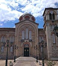
The stone-built church of Saint Basil in Selianitika (Summer 2018).

Square beside the sea at the coastal front of Selianitika (Spring 2018)

Medicinal sulphurous baths of Selianitika

View of the fine gravel beach in the summer

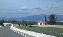
Panoramic view of Selianitika and Longos from the nearby hills

Selianitika-Longos interchange, Motorway 8, Olympia Odos

Rail overpass in Selianitika. Part of the new (under construction) Railway line Athens-Patras (April 2018)
The former Selianitika railway station.(April 2018)


References[]
- ^ Jump up to: a b "Απογραφή Πληθυσμού - Κατοικιών 2011. ΜΟΝΙΜΟΣ Πληθυσμός" (in Greek). Hellenic Statistical Authority.
- ^ "Interactive Map - Olympia Odos".
- ^ [1] View of the construction works for the new railway in the village of Selianitika
- ^ [2] ERGOSE railway Project "Rododafni – Patra (Bozaitika area) (Superstructure, Electrification, Stops)"
- ^ Voyage en Grèce (Paris, 1820–1822, 5 vol. in-8° ; 20 édit., 1826–1827, 6 vol. in-8°)
- ^ Ludwig, Salvador. Eine Spazierfahrt Im Golfe Von Korinth. Prag: Heinr. Mercy, 1876, p. 275 (available online in books.google.com, in German)
- ^ [3] Official document of Greece's population census of 1879 (in Greek)
- ^ List of Local mineral springs of Greece(Greek Ministry of Tourism)
- ^ Thermal Mineral waters of Western Greece , page 36 (Stratikopoulos K. - Master Thesis - Department of Geology - University of Patras - 2007 (in Greek))
External links[]
- Cultural association of Selianitika "Helios" (In Greek)
- Selianitika on GTP Travel Pages
- Official website of the municipality of Sympoliteia (in Greek)
Sources[]
- Αθ. Φωτόπουλος, "Ιστορικά και Λαογραφικά της Ανατολικής Αιγιάλειας και Καλαβρύτων", Αθήνα 1982 (In Greek)
- K. Baedeker, "Griechenland - Handbuch fuer Reisende", Leipzig, 1893 (In German)
See also[]
- Aigialeia
- Populated places in Achaea