Selje (village)
Selje | |
|---|---|
Village | |
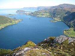 View of the village | |
 Selje Location in Vestland | |
| Coordinates: 62°02′40″N 5°20′51″E / 62.0444°N 5.3474°ECoordinates: 62°02′40″N 5°20′51″E / 62.0444°N 5.3474°E | |
| Country | Norway |
| Region | Western Norway |
| County | Vestland |
| District | Nordfjord |
| Municipality | Stad Municipality |
| Area | |
| • Total | 0.77 km2 (0.30 sq mi) |
| Elevation | 10 m (30 ft) |
| Population (2018)[1] | |
| • Total | 724 |
| • Density | 940/km2 (2,400/sq mi) |
| Time zone | UTC+01:00 (CET) |
| • Summer (DST) | UTC+02:00 (CEST) |
| Post Code | 6740 Selje |


Selje is a village in Stad Municipality in Vestland county, Norway. The village is located at the southwestern base of the Stadlandet peninsula at the entrance to the . The village lies about 17 kilometres (11 mi) northeast of the town of Måløy and about 65 kilometres (40 mi) southwest of the town of Ålesund. The small island of Selja lies just off the coast of the village. Selje Church is located in the village.[3]
The 0.77-square-kilometre (190-acre) village has a population (2018) of 724 and a population density of 940 inhabitants per square kilometre (2,400/sq mi).[1]
The village was the administrative centre of the old Selje Municipality until 2020 when it was merged into Stad Municipality.
References[]
- ^ Jump up to: a b c Statistisk sentralbyrå (1 January 2018). "Urban settlements. Population and area, by municipality".
- ^ "Selje (Sogn og Fjordane)". yr.no. Retrieved 2019-10-06.
- ^ Store norske leksikon. "Selje tettsted" (in Norwegian). Retrieved 2013-09-11.
| Authority control |
|
|---|
This Vestland location article is a stub. You can help Wikipedia by . |
- Stad, Norway
- Villages in Vestland
- Vestland geography stubs