Semenov Peak
This article needs additional citations for verification. (May 2020) |
| Semenov Peak | |
|---|---|
| Pik Semonova | |
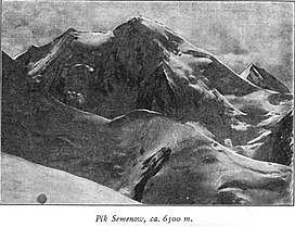 Taken by German geographer Gottfried Merzbacher in 1902/3 | |
| Highest point | |
| Elevation | 5,816 m (19,081 ft)[1] |
| Prominence | 802 m (2,631 ft)[1] |
| Coordinates | 42°16′34″N 80°7′5″E / 42.27611°N 80.11806°ECoordinates: 42°16′34″N 80°7′5″E / 42.27611°N 80.11806°E |
| Geography | |
 Semenov Peak | |
| Parent range | Tian Shan |


Semenov Peak (Russian: Пик Семёнова, romanized: Pik Semonova) is a mountain in the Tian Shan on the border between Kyrgyzstan and Kazakhstan.[2]
The 5,816-metre (19,081 ft) high mountain is located 8.64 km northwest of Khan Tengri (6995 m) on the opposite side of the Northern Engilchek Glacier.
The peak is named after the Russian geographer Peter Semenov.
References[]
- ^ a b "Semionova". Peakbagger.com. Retrieved 2020-11-20.
- ^ "Pik Semenova". peakvisor.com. Retrieved 2020-11-20.
This Asia mountain, mountain range, or peak related article is a stub. You can help Wikipedia by . |
This Almaty Region location article is a stub. You can help Wikipedia by . |
Categories:
- Mountains of Kazakhstan
- Mountains of Kyrgyzstan
- Five-thousanders of the Tian Shan
- Issyk-Kul Region
- Landforms of Almaty Region
- Kazakhstan–Kyrgyzstan border
- International mountains of Asia
- Asia mountain stubs
- Almaty geography stubs
- Issyk Kul geography stubs