Senafe
This article needs additional citations for verification. (August 2020) |
Senafe
ሰንዓፈ صنعفى | |
|---|---|
 | |
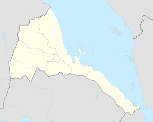 Senafe Location in Eritrea | |
| Coordinates: 14°42′N 39°25′E / 14.700°N 39.417°E | |
| Country | |
| Region | Debub. جنوب |
| District | Senafe District |
| Elevation | 2,446 m (8,025 ft) |
| Climate | BSk |
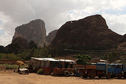
Senafe صنعفى , Tigrinya: ሰንዓፈ is a market town in southern Eritrea, on the edge of the Eritrean highlands. The surrounding area is inhabited by the Saho people and the Tigrinya people.
Senafe is known for the ruins of Metera (also known as Balaw Kalaw) to the south, and for Kaskase to the north. The soil is derived from volcanic ignimbrite,[1] and Senafe sits on the southeastern edge of a twenty kilometer wide caldera.
History[]
The original name for Saanafè was "Hakir", an Agazian word. Local tradition states that the name was changed by a man named Abdullah from Sana'a in Yemen; he settled in the Awdie district of Hakir, and upon marrying a local woman he was quoted as saying "Sana-fen" which means in Arabic "where is Sana'a" he was relating to his hometown; thus the town was named Sanafe; his descendants form a tribe and are also known as Saanafè.
An early record of Sanafe is on the , published in 1454. This map shows Sanafe at the Southern part of Eritrea.
Due to war (1998-2000) between Eritrea and Ethiopia, Senafe's economy was damaged badly. The highest mountain located in the Senafe municipality is Soira. Other high mountains that surrounded Senafe include: Metera, Arab-tarika and Emba Derho.

View of the plateau at Senafe

The Abessinian Expedition : The naval Rocket brigade firing rockets at Senafe (1868).


During Italian rule, the town grew notably: The modern town suffered extensive destruction during the Eritrean War of Independence and the Eritrean-Ethiopian War, although people are gradually returning from its surrounding refugee camps.[2]
Climate[]
The prevailing climate in Senafe is known as a steppe climate.
| Climate data for Senafe | |||||||||||||
|---|---|---|---|---|---|---|---|---|---|---|---|---|---|
| Month | Jan | Feb | Mar | Apr | May | Jun | Jul | Aug | Sep | Oct | Nov | Dec | Year |
| Average high °C (°F) | 24.0 (75.2) |
25.2 (77.4) |
26.5 (79.7) |
26.7 (80.1) |
27.1 (80.8) |
26.7 (80.1) |
22.3 (72.1) |
22.7 (72.9) |
25.2 (77.4) |
24.6 (76.3) |
23.5 (74.3) |
23.1 (73.6) |
24.8 (76.7) |
| Average low °C (°F) | 7.6 (45.7) |
8.6 (47.5) |
10.3 (50.5) |
11.4 (52.5) |
11.9 (53.4) |
11.5 (52.7) |
11.2 (52.2) |
11.9 (53.4) |
10.4 (50.7) |
9.5 (49.1) |
8.3 (46.9) |
7.0 (44.6) |
10.0 (49.9) |
| Average rainfall mm (inches) | 4 (0.2) |
7 (0.3) |
25 (1.0) |
59 (2.3) |
41 (1.6) |
31 (1.2) |
158 (6.2) |
135 (5.3) |
21 (0.8) |
10 (0.4) |
20 (0.8) |
4 (0.2) |
515 (20.3) |
| Source: Climate-Data.org, altitude: 2446m [3] | |||||||||||||
Notes and references[]
| Wikimedia Commons has media related to Senafe. |
- ^ Zanettin, Bruno; Bellieni, Giuliano; Visentin, Eleonora Justin (2006). "Stratigraphy and evolution of the trachy-rhyolitic volcanism of the Senafe area (Eastern Eritrean Plateau)". Journal of African Earth Sciences. 45 (4/5): 478–488. doi:10.1016/j.jafrearsci.2006.04.004.
- ^ Okubaghergis, Biyan Ghebreyesus. (2020) "The Impact of the Eritrean-Ethiopian Border on the Borderland Communities (2000-2018): A case Study of Senafe and Tserona." PHD thesis, University of Cagliari. Requires subscription.
- ^ "Climate: Senafe - Climate graph, Temperature graph, Climate table". Climate-Data.org. Retrieved 25 September 2014.
- Southern Region (Eritrea)
- Populated places in Eritrea