Sentinel Gap
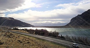
Sentinel Gap is a water gap formed by the Columbia River in the Saddle Mountains, near Mattawa in Washington state.[1] The gap is "a water gap where erosion by the Columbia River was able to keep pace with folding, faulting and uplifting across the Saddle Mountain anticline".[2] During Ice Age floods in which waters from the Channeled Scablands found passage to the Pacific Ocean here and at Wallula Gap,[3] this opening was "repeatedly reamed out, which probably widened and steepened the walls of the gap".[2] Strandlines from the floods can be seen on the basalt walls of the gap.[4][5]
SR 243 runs along the east side of the river through the gap, and the river is spanned by the Beverly Railroad Bridge.[6] The gap is located between the Wanapum and Priest Rapids dams. Priest Rapids, for which the dam was named, are now submerged beneath the dam's reservoir about 4 miles (6.4 km) downstream from Sentinel Gap.
References[]
- ^ U.S. Geological Survey Geographic Names Information System: Sentinel Gap
- ^ a b Bjornstad 2006, p. 242.
- ^ Soehnichsen 2012, pp. 154–155.
- ^ Bjornstad 2006, p. 92.
- ^ Tom Foster (November 7, 2009), "Sentinel Gap and Mattawa Bar", Ice Age Floods: Glacial Lake Missoula, Lake Bonneville and the Ice Age Floods
- ^ Lindsey, Kevin (July 25, 1983). "Columbia's early course visible at Sentinel Gap". Tri-City Herald. p. D6.
Sources[]
- Bjornstad, Bruce N. (2006), On the Trail of the Ice Age Floods: A Geological Field Guide to the Mid-Columbia Basin, Keokee Books, ISBN 9781879628274, OCLC 70697754
- Soehnichsen, John (2012), Washington's Channeled Scablands Guide, The Mountaineers Books, ISBN 978-1-59485-483-5, OCLC 910880058
External links[]
 Media related to Sentinel Gap at Wikimedia Commons
Coordinates: 46°48′19″N 119°56′02″W / 46.80528°N 119.93389°W

This Kittitas County, Washington state location article is a stub. You can help Wikipedia by . |
- Columbia River
- Landforms of Kittitas County, Washington
- Water gaps of Washington
- Central Washington geography stubs