Sentinel Rock
| Sentinel Rock | |
|---|---|
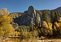
 A photo of Sentinel Rock in Yosemite Valley, taken by Tom Frost | |
| Highest point | |
| Elevation | 7,038 ft (2,145 m)[1] |
| Coordinates | 37°43′44″N 119°35′40″W / 37.7288151°N 119.594331°WCoordinates: 37°43′44″N 119°35′40″W / 37.7288151°N 119.594331°W[2] |
| Geography | |
| Location | Yosemite National Park Mariposa County, California, U.S. |
| Parent range | Sierra Nevada |
| Topo map | USGS Half Dome |
| Geology | |
| Age of rock | Cretaceous |
| Type of rock | Granite |
| Climbing | |
| First ascent | June 30 - July 4, 1950 by Allen Steck and John Salathé[3] |
| Easiest route | Circular Staircase (class 5.8)[4] |

Sentinel Rock is a granitic peak in Yosemite National Park, California, United States. It towers over Yosemite Valley, opposite Yosemite Falls.[5] Sentinel Rock lies 0.7 miles (1.1 km) northwest of Sentinel Dome.
How it was formed[]
Sentinel Rock formed when masses of rock split off Yosemite Valley's south-side cliff, along steep joints trending nearly east–west. This formed the near-vertical north face of Sentinel Rock.[6]
Climbing[]
The most famous climbing route is the Steck-Salathé route, which is rated a class 5.10b G A0.[3]
Climber Derek Hersey died while attempting to free solo climb Sentinel Rock in 1993.[7]
Gallery[]
Northwest aspect


Sentinel Rock (right) in Yosemite Valley. (camera pointed east)

Sentinel Rock postcard, circa 1901


References[]
- ^ "Natural Resource Statistics". Yosemite National Park. National Park Service. Retrieved 2009-01-28.
- ^ "Sentinel Rock". Geographic Names Information System. United States Geological Survey. Retrieved 2009-01-28.
- ^ a b "Steck-Salathe". rockclimbing.com. Retrieved 2014-01-20.
- ^ "Circular Staircase, Sentinel Rock 5.8". SuperTopo.com. Retrieved 2016-03-27.
- ^ "Rock Formations in Yosemite". Yosemite National Park. National Park Service. Retrieved 2007-08-14.
- ^ USGS Geology and Geophysics: USGS Geology and Geophysics, accessdate: March 20, 2017
- ^ Roberts, Paul (1994-11-01). "Risk". Psychology Today. Retrieved 2011-07-27.
External links[]
 Media related to Sentinel Rock at Wikimedia Commons
This Mariposa County, California–related article is a stub. You can help Wikipedia by . |
- Mountains of Mariposa County, California
- Mountains of Yosemite National Park
- Mountains of Northern California
- Climbing areas of California
- Mariposa County, California geography stubs