Sept-Îles, Quebec
Sept-Îles
(Uashat) | |
|---|---|
City | |
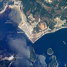
 Sept-Îles in August 2008 | |
 Coat of arms | |
 Sept-Îles Location in Côte-Nord region of Quebec. | |
| Coordinates: 50°13′N 66°23′W / 50.217°N 66.383°WCoordinates: 50°13′N 66°23′W / 50.217°N 66.383°W[1] | |
| Country | Canada |
| Province | Quebec |
| Region | Côte-Nord |
| RCM | Sept-Rivières |
| Constituted | February 12, 2003 |
| Government | |
| • Mayor | Réjean Porlier |
| • Federal riding | Manicouagan |
| • Prov. riding | Duplessis |
| Area | |
| • City | 2,140.10 km2 (826.30 sq mi) |
| • Land | 1,764.13 km2 (681.13 sq mi) |
| • Urban | 19.69 km2 (7.60 sq mi) |
| • Metro | 1,770.52 km2 (683.60 sq mi) |
| Population (2016)[3] | |
| • City | 28,534 |
| • Density | 16.1/km2 (42/sq mi) |
| • Urban | 23,326 |
| • Urban density | 1,184.5/km2 (3,068/sq mi) |
| • Metro | 28,487 |
| • Metro density | 16.1/km2 (42/sq mi) |
| • Pop 2011-2016 | |
| • Dwellings | 12,275 |
| Time zone | UTC−5 (EST) |
| • Summer (DST) | UTC−4 (EDT) |
| Postal code(s) | G4R, G4S |
| Area code(s) | 418 and 581 |
| Highways | |
| Website | www |

Sept-Îles (French pronunciation: [sɛ.t‿il], Quebec French pronunciation : [sɛ.t͡s‿ɪl] (![]() listen), French for "Seven Islands") is a city in the Côte-Nord region of eastern Quebec, Canada. It is among the northernmost locales with a paved connection to the rest of Quebec's road network. The population was 25,686 as of the Canada 2011 Census. The town is called Uashat, meaning "bay," in the Innu language.[6]
listen), French for "Seven Islands") is a city in the Côte-Nord region of eastern Quebec, Canada. It is among the northernmost locales with a paved connection to the rest of Quebec's road network. The population was 25,686 as of the Canada 2011 Census. The town is called Uashat, meaning "bay," in the Innu language.[6]
The city is well known for having major iron companies like Iron Ore Company of Canada and the Cleveland-Cliffs mining company. The city relies heavily on the iron industry. Sept-Îles has among the highest average wages and the highest average wage increases.[7]
The only settlements on the paved road network that are farther north are Fermont, Radisson and Chisasibi, the latter two of which are in the extreme western part of the province at the north end of the James Bay Road. The only other settlements at higher latitudes in the province are mostly isolated Cree, Innu, or Inuit villages, with access limited to seasonal gravel roads.
Sept-Îles is the seat of the judicial district of Mingan.[8] The city is also home to the most highly attended recreational sport events in the province: the Tournoi Orange volleyball tournament, which consists of 405 teams and close to 800 volleyball games.[9]
History and economy[]
The first inhabitants of the area were varying cultures of indigenous peoples. The historic Montagnais or Innu people, who called it Uashat ("Great Bay"), lived there at the time of European encounter. Jacques Cartier sailed by the islands in 1535 and made the first written record of them, calling them the Ysles Rondes ("Round Islands"). He was not the first European in the area, as he encountered Basque fishermen who came annually from Europe for whaling and cod fishing.
Early European economic activity in Sept-Îles was based on fishing and the fur trade. Louis Joliet established trading posts by 1679. Great Britain took over Canada from France in 1763 after its victory in the Seven Years' War. In 1842 the Hudson's Bay Company founded another post at this location. The village was incorporated into a municipality in 1885.
Lacking road access at the time, the town got its first pier in 1908. The City of Sept-Îles was incorporated in 1951, on the 300th anniversary of the first Catholic Mass held in the village.
The modern Sept-Îles was built rapidly during the construction of the Quebec North Shore and Labrador Railway, the 357-mile (575 km) railway link to the northern town of Schefferville. The railway was built between 1950 and 1954 by the Iron Ore Company of Canada. Iron ore mined near Schefferville and Wabush, Labrador, was transported on this railway and shipped from the Port of Sept-Îles. Shipment of the important new commodity resulted in investments that turned this into a major port.[10]

With the iron ore business, the Sept-Îles deep-water seaport was second in Canada only to Vancouver in terms of yearly tonnage. The huge engineering project led to a major increase in population, and housing was quickly built to accommodate them. The town grew from 2,000 inhabitants in 1951 to 14,000 in 1961, and 31,000 in 1981. The decline in worldwide iron ore prices in recent decades has since caused employment and population to decrease.
During the early 1990s, some new jobs accompanied the construction and operation of the new Aluminerie Alouette inc. aluminum processing plant. Construction for Phase 1 began in September 1989, and operation started in 1992. Construction of Phase 2 began in 2003.
In 2002 the city amalgamated with the communities of Gallix and Moisie. The city includes the neighbourhoods of Arnaud, Clarke, De Grasse, de la Pointe, de la Rivière, Ferland, La Boule, Lac Labrie, Matamec, Plages, Pointe-Noire and Val-Marguerite.
Transportation[]
The Sept-Îles Airport has connections all over Quebec and Labrador. General aviation seaplanes are served by Sept-Îles/Lac Rapides Water Aerodrome. Air Gaspé was based in Sept-Îles, but acquired by Quebecair in 1973. In the 1980s, continued airline restructuring led to Quebecair's being acquired by CP Air in 1986, which in turn was taken over by Canadian Airlines in 1987.
Tshiuetin Rail Transportation also operates a passenger rail service north to Emeril, Labrador (near Labrador City) which continues northward towards its terminus in Schefferville, Quebec.
Geography[]
Located on the north shore of the Saint Lawrence River, between the Sainte-Marguerite and Moisie rivers, Sept-Îles lies on the shore of a deep-water bay fronted by a seven-island archipelago, about 230 kilometres east of Baie-Comeau. The bay constitutes a 45 km² natural harbour.
The seven islands are named:
- La Grosse Boule ("the big ball")
- La Petite Boule ("the small ball")
- La Grande Basque ("the large Basque", named after the visiting Basque fishermen)
- La Petite Basque ("the small Basque")
- Île Manowin (from the Montagnais manouane meaning "where eggs are picked")
- Île du Corossol (named after the French ship Corossol wrecked on the island in 1693; site of a lighthouse and a bird sanctuary)
- Îlets Dequen (a group of tiny islands named after Jean de Quen who founded the local Catholic mission in 1650)
The archipelago is under provincial jurisdiction, with some parts administered by the federal government or by individuals.
There are two First Nations reserves in the area: Uashat in the western city proper, and Maliotenam in the east near the Moisie River.
Demographics[]
Population[]
| hideCanada census – Sept-Îles, Quebec community profile | |||
|---|---|---|---|
| 2011 | 2006 | ||
| Population: | 25,686 (+0.7% from 2006) | 25,514 (+0.5% from 2001) | |
| Land area: | 1,764.13 km2 (681.13 sq mi) | 1,764.26 km2 (681.18 sq mi) | |
| Population density: | 14.6/km2 (38/sq mi) | 14.5/km2 (38/sq mi) | |
| Median age: | 42.1 (M: 41.7, F: 42.4) | 40.6 (M: 40.6, F: 40.6) | |
| Total private dwellings: | 12,029 | 11,887 | |
| Median household income: | $62,441 | $51,872 | |
| References: 2011[3] 2006[11] earlier[12] | |||
|
|
|
Language[]
In the urban area of Sept-Îles, 86.2% of the population reported French only as mother tongue, 10.3% reported only a native (Innu language) or non-official language, and 2.7% reported English only, in 2011.[14]
| Canada Census Mother Tongue - Sept-Îles, Quebec[13] | ||||||||||||||||||
|---|---|---|---|---|---|---|---|---|---|---|---|---|---|---|---|---|---|---|
| Census | Total | French
|
English
|
French & English
|
Other
| |||||||||||||
| Year | Responses | Count | Trend | Pop % | Count | Trend | Pop % | Count | Trend | Pop % | Count | Trend | Pop % | |||||
2011
|
25,295
|
23,875 | 94.39% | 745 | 2.94% | 160 | 0.63% | 515 | 2.04% | |||||||||
2006
|
25,190
|
23,460 | 93.13% | 760 | 3.02% | 155 | 0.62% | 815 | 3.23% | |||||||||
2001
|
23,630
|
22,265 | 94.22% | 785 | 3.32% | 235 | 0.99% | 345 | 1.46% | |||||||||
1996
|
25,040
|
23,655 | n/a | 94.47% | 885 | n/a | 3.53% | 140 | n/a | 0.56% | 360 | n/a | 1.44% | |||||
Climate[]
Sept-Îles has a subarctic climate (Köppen climate classification Dfc) bordering on a humid continental climate (Dfb) despite being located at around only 50 degrees latitude. The two main seasons are summer and winter, as spring and autumn are very short transition seasons lasting only a few weeks. Winters are long, cold, and snowy, lasting from late October to late April, but milder than more inland locations, with a January high of −9.8 °C (14.4 °F) and a January low of −20.9 °C (−5.6 °F). Overall precipitation is unusually high for a subarctic climate, and snow totals correspondingly heavy, averaging 385 centimetres (152 in) per season with an average maximum depth of 0.5 metres (1.6 ft). Summers are mild, with a July high of 19.6 °C (67.3 °F); summers thus display stronger maritime influence than do winters. Precipitation is significant year-round, but it is lowest from January to March.
The highest temperature ever recorded in Sept-Îles was 37.4 °C (99 °F) on 18 June 2020.[15] The coldest temperature ever recorded was −45.6 °C (−50 °F) on 29 January 1913.[16] The coldest temperature was recorded at Clarke City, which was the primary weather station for the area until records began at Sept-Îles Airport in September 1944.[17][18]
| hideClimate data for Sept-Îles Airport, 1981−2010 normals, extremes 1903−present[a] | |||||||||||||
|---|---|---|---|---|---|---|---|---|---|---|---|---|---|
| Month | Jan | Feb | Mar | Apr | May | Jun | Jul | Aug | Sep | Oct | Nov | Dec | Year |
| Record high °C (°F) | 10.0 (50.0) |
10.6 (51.1) |
16.4 (61.5) |
22.8 (73.0) |
29.4 (84.9) |
37.4 (99.3) |
33.9 (93.0) |
35.6 (96.1) |
30.0 (86.0) |
25.6 (78.1) |
17.2 (63.0) |
9.4 (48.9) |
37.4 (99.3) |
| Average high °C (°F) | −9.8 (14.4) |
−7.9 (17.8) |
−1.9 (28.6) |
4.0 (39.2) |
10.7 (51.3) |
16.5 (61.7) |
19.5 (67.1) |
19.1 (66.4) |
14.2 (57.6) |
7.8 (46.0) |
1.0 (33.8) |
−5.6 (21.9) |
5.6 (42.1) |
| Daily mean °C (°F) | −15.3 (4.5) |
−13.6 (7.5) |
−6.8 (19.8) |
0.2 (32.4) |
6.2 (43.2) |
11.8 (53.2) |
15.2 (59.4) |
14.4 (57.9) |
9.8 (49.6) |
3.7 (38.7) |
−2.9 (26.8) |
−10.5 (13.1) |
1.0 (33.8) |
| Average low °C (°F) | −20.8 (−5.4) |
−19.3 (−2.7) |
−11.7 (10.9) |
−3.7 (25.3) |
1.7 (35.1) |
7.0 (44.6) |
10.8 (51.4) |
9.8 (49.6) |
5.3 (41.5) |
−0.4 (31.3) |
−6.7 (19.9) |
−15.3 (4.5) |
−3.6 (25.5) |
| Record low °C (°F) | −45.6 (−50.1) |
−43.3 (−45.9) |
−37.2 (−35.0) |
−26.4 (−15.5) |
−16.1 (3.0) |
−7.8 (18.0) |
−3.3 (26.1) |
−0.7 (30.7) |
−7.8 (18.0) |
−18.9 (−2.0) |
−28.9 (−20.0) |
−38.3 (−36.9) |
−45.6 (−50.1) |
| Average precipitation mm (inches) | 81.7 (3.22) |
68.6 (2.70) |
81.3 (3.20) |
92.1 (3.63) |
86.9 (3.42) |
99.1 (3.90) |
104.4 (4.11) |
84.4 (3.32) |
108.7 (4.28) |
104.1 (4.10) |
109.2 (4.30) |
99.4 (3.91) |
1,119.9 (44.09) |
| Average rainfall mm (inches) | 8.3 (0.33) |
13.9 (0.55) |
24.4 (0.96) |
49.2 (1.94) |
76.7 (3.02) |
99.1 (3.90) |
104.4 (4.11) |
84.4 (3.32) |
108.7 (4.28) |
98.0 (3.86) |
62.4 (2.46) |
18.1 (0.71) |
747.5 (29.43) |
| Average snowfall cm (inches) | 84.1 (33.1) |
59.7 (23.5) |
57.8 (22.8) |
36.4 (14.3) |
8.1 (3.2) |
0.0 (0.0) |
0.0 (0.0) |
0.0 (0.0) |
0.05 (0.02) |
5.3 (2.1) |
46.0 (18.1) |
87.2 (34.3) |
384.6 (151.4) |
| Average precipitation days (≥ 0.2 mm) | 16.5 | 13.4 | 13.7 | 12.7 | 13.8 | 13.6 | 16.4 | 14.1 | 13.7 | 15.5 | 14.9 | 15.6 | 173.8 |
| Average rainy days (≥ 0.2 mm) | 1.4 | 1.6 | 3.9 | 7.8 | 13.2 | 13.6 | 16.4 | 14.1 | 13.8 | 14.4 | 8.3 | 2.7 | 111.0 |
| Average snowy days (≥ 0.2 cm) | 16.4 | 12.5 | 12.4 | 7.7 | 1.7 | 0.0 | 0.0 | 0.0 | 0.1 | 2.5 | 9.7 | 14.8 | 77.7 |
| Mean monthly sunshine hours | 104.0 | 134.4 | 150.8 | 170.1 | 223.4 | 221.2 | 240.9 | 220.4 | 154.0 | 131.2 | 93.5 | 93.7 | 1,937.6 |
| Source: Environment Canada,[19][20] (sun 1961−1990),[21] Clarke City (1903−1944)[22][16][17] | |||||||||||||
Tourism[]
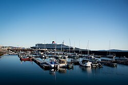
Since 2009, Sept-Îles has been part of the Saint-Laurent destination circuit, which has nine international cruise ports. On a larger scale, an alliance is being created with other ports in Northeastern America and Canada under the auspices of Canada New England. The international cruises in Sept-Îles are led by the non-profit organization Destination Sept-Îles Nakauinanu. The organization's mission is to enable the various public and private bodies to enjoy a permanent structure, in the form of a one-stop shop, enabling them to work jointly on the development and promotion of the City of Sept-Îles and from its surroundings to international cruise lines. The main partners involved in the development of international cruises are the City of Sept-Îles, the Port of Sept-Îles and Innu Takuaikan Uashat mak Mani-Utenam.
As of 2018, more than 55,000 international visitors have visited the port of call. Cunard, P & O Cruises, Cruise and Maritime Voyages, Phoenix Reisen, Holland America Line, Oceania Cruises, Regent Seven Seas, Silversea, Saga Cruises, Crystal Cruises, Norwegian Cruise Line, Pearl Seas Cruises and Transocean Tours are among the clients of the port. On September 7, 2019, when Royal Caribbean Line made its maiden call overnight, this was a safe haven for avoiding Hurricane Dorian.
Media[]
Radio[]
- FM 90.1 - CKAU-FM-1, First Nations community radio (rebroadcasts CKAU-FM Maliotenam)
- FM 94.1 - CKCN-FM, contemporary hit radio
- FM 96.1 - CBRX-FM-2, Ici Musique (rebroadcasts CBRX-FM Rimouski)
- FM 96.9 - CBSE-FM, CBC Radio One (rebroadcasts CBVE-FM Quebec City)
- FM 98.1 - CBSI-FM, Ici Radio-Canada Première
- FM 99.1 - CIPC-FM, soft rock
Television[]
All terrestrial television stations in the Sept-Îles area are repeaters of stations and networks that originate elsewhere. These stations are available on the Cogeco cable system, which also offer a local cable channel, TVCogeco. The local Cogeco system also carries CBMT-DT (CBC) Montreal and CJBR-DT (Ici Radio-Canada Télé) Rimouski.
Sept-Îles is not designated as a mandatory market for digital television conversion; only CFTF-TV and Télé-Québec announced their intentions to convert all their transmitters to digital, regardless of location.
- Channel 5 / DT 20 - CFER-TV-2, TVA (rebroadcasts CFER-TV Rimouski)
- Channel 7 / PSIP 7 - CFTF-DT-7, V (rebroadcasts CFTF-DT Rivière-du-Loup)
- Channel 9 / PSIP 9 - CIVG-DT, Télé-Québec (rebroadcasts CIVM-DT Montreal)
Economy[]
Iron ore concentrate from IOC activities in Labrador City are transported by the Quebec North Shore and Labrador Railway and are shipped to many markets around the world from Sept-Îles port facilities. Iron ore from Wabush and Bloom Lake is also shipped at Point Noire port facilities. The Aluminerie Alouette, in activity since 1992 has a large part in the local employment since his construction started in 1989. Since its major expansion that started in 2005, it is now the largest primary aluminum smelter in the Americas. As a service centre for northeastern Québec, Sept-Îles economy is also powered by many jobs in the services sector.
Prior to its disestablishment, Air Gaspé was headquartered in Sept-Îles.[23]
Notable people[]
- Guy Carbonneau, Hall of Famer, former NHL defensive forward, former coach with the Montreal Canadiens
- Karen Cliche, actress
- Louis Jolliet, bought some land and the fur trading post.
- Louis-Jean Cormier, vocalist and guitarist of the band Karkwa
- Steve Duchesne, former NHL defenseman
- Karl Dykhuis, former NHL defenseman
- Guillaume LeBlanc, Olympic silver medalist in walking
- Claude McKenzie, singer-songwriter and member of the group Kashtin
- Bruno Pauletto, physiologist, athlete, businessman, coach, author
- Henry de Puyjalon, (1841-1905) scientist, pioneer in ecology
- Myriam Sirois, actress
- Robert Michael Ballantyne, former-explorer who traded furs
- Florent Vollant, singer-songwriter and member of the group Kashtin
- Rob Zettler, former NHL defenseman
- Margot Kidder, was born in 1948 as "a Stanton baby". Throughout her childhood, she moved to a number of Canadian towns, including Labrador City, N.L., Beloeil, Que., and Sept-Îles, Que.
- Pierre Bourgault, Political activist and pioneer of the Quebec separatist movement tried to be elected in the Sept-Îles provincial district (Duplessis)
- Pierre Duchesne, ex-Lieutenant Governor of Quebec did his notary career in Sept-Îles
- , musician
In popular culture[]
- Gordon Lightfoot's song entitled "Seven Island Suite" is about this region.
See also[]
Notes and references[]
- ^ Reference number 98695 of the Commission de toponymie du Québec (in French)
- ^ Jump up to: a b Ministère des Affaires municipales, des Régions et de l'Occupation du territoire - Répertoire des municipalités: Sept-Îles
- ^ Jump up to: a b c "2011 Community Profiles". 2011 Canadian Census. Statistics Canada. July 5, 2013. Retrieved 2014-02-21.
- ^ Jump up to: a b [1]
- ^ Jump up to: a b Statistics Canada 2011 Census Census Profiles: Sept-Îles (Census agglomeration). The census agglomeration consists of Sept-Îles, Maliotenam, Uashat. This was unchanged from the 2006 census.
- ^ Innu-aimun.ca: Uashau
- ^ "Côte-Nord : croissance de l'écart entre les riches et les pauvres à Sept-Îles". Cite journal requires
|journal=(help) - ^ Territorial Division Act. Revised Statutes of Quebec D-11.
- ^ "Sept-Îles est "Orange"!". Cite journal requires
|journal=(help) - ^ "The Iron Road To Labrador." Popular Mechanics, February 1954, pp. 118-124.
- ^ "2006 Community Profiles". 2006 Canadian Census. Statistics Canada. March 30, 2011. Retrieved 2014-02-21.
- ^ "2001 Community Profiles". 2001 Canadian Census. Statistics Canada. February 17, 2012.
- ^ Jump up to: a b Statistics Canada: 1996, 2001, 2006, 2011 census
- ^ "Focus on Geography Series, 2011 Census".
- ^ "Daily Data Report for June 2020". Canadian Climate Data. Environment Canada. Retrieved 23 July 2020.
- ^ Jump up to: a b "January 1913". Canadian Climate Data. Environment Canada. Retrieved 22 June 2016.
- ^ Jump up to: a b "Clarke City". Canadian Climate Data. Environment Canada. Retrieved 22 June 2016.
- ^ "Sept-Îles A". Canadian Climate Data. Environment Canada. Retrieved 22 June 2016.
- ^ "Sept-Îles A, Quebec". Canadian Climate Normals 1981–2010. Environment Canada. Retrieved November 25, 2013.
- ^ "March 2012". Canadian Climate Data. Environment Canada. Retrieved 22 June 2016.
- ^ Climate Normals for Sept-Îles 1961-1990 , Accessed March 10, 2012.
- ^ "August 1928". Canadian Climate Data. Environment Canada. Retrieved 22 June 2016.
- ^ World Airline Directory. Flight International. March 20, 1975. "466.
- ^ Trains (Magazine) February 2009 p9
- Dredge, L. A. Surficial Geology of the Sept-Îles Area, Quebec North Shore. Ottawa, Canada: Geological Survey of Canada, 1983.
- Faessler, Carl. Sept-Îles Area, North Shore of St. Lawrence, Saguenay County. Québec: Dept. of Mines, Division of Geological Surveys, 1942.
- ^ Extreme high and low temperatures were recorded in Clarke City from May 1903 to August 1944, and at Sept-Îles Airport from September 1944 to present.
External links[]
| Wikimedia Commons has media related to Sept-Îles. |
 Sept-Îles travel guide from Wikivoyage
- (in French) Ville de Sept-Îles
| show Adjacent Municipal Subdivisions |
|---|
| hide | |||||
|---|---|---|---|---|---|
| Administrative units |
| ||||
| Protected areas |
| ||||
| Major river basins | |||||
| Significant lakes | |||||
| Transport infrastructure | |||||
| |||||
| show Authority control |
|---|
- Sept-Îles, Quebec
- Cities and towns in Quebec
- Quebec populated places on the Saint Lawrence River
- Hudson's Bay Company trading posts
- Port settlements in Quebec