Sevan Island
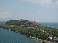
 Sevan Peninsula from afar. | |
| Geography | |
|---|---|
| Location | |
| Coordinates | 38°20′30″N 43°02′07″E / 38.341667°N 43.035278°ECoordinates: 38°20′30″N 43°02′07″E / 38.341667°N 43.035278°E |
| Highest elevation | 1,950 m (6400 ft) |

Sevan Island (Armenian: Սևանի կղզի Sevani kğzi), now Sevan Peninsula (Armenian: Սևանի թերակղզի Sevani t'erakğzi) was an island in the northwestern part of Lake Sevan in Armenia. After the artificial draining of Lake Sevan, which started in the Joseph Stalin era, the water level fell about 20 metres, and the island transformed into a peninsula. At the southern shore of this newly created peninsula, a guesthouse of the Armenian Writers' Union was built. The eastern shore is occupied by the Armenian president's summer residence, while the monastery's still active seminary moved to newly constructed buildings at the northern shore of the peninsula.
Sevan Island is home to a ninth-century Armenian Cathedral church, known as Sevanavank, which is one of the most visited tourist attractions in Armenia.
Gallery[]
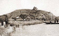
The island and the monastery of Sevan during the 19th century (Paris, 1869, T. Deyrolle)
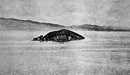
Sevan Island in 1937

1974
2012

2017


Panorama[]

See also[]
References[]
- "Sevan Island, Armenia 1970s - LAPUTA". Retrieved 17 January 2016.
- "Gegharquniq - armecotravel.com". Retrieved 17 January 2016.
This Armenia location article is a stub. You can help Wikipedia by . |
- Islands of Armenia
- Landforms of Armenia
- Geography of Gegharkunik Province
- Peninsulas of Asia
- Armenia geography stubs