Seymour Airport
Seymour Galapagos Ecological Airport | |||||||||||
|---|---|---|---|---|---|---|---|---|---|---|---|
 | |||||||||||
| Summary | |||||||||||
| Airport type | Public / Military | ||||||||||
| Serves | Baltra, Galápagos Islands, Ecuador | ||||||||||
| Elevation AMSL | 207 ft / 63 m | ||||||||||
| Coordinates | 00°27′14″S 90°15′57″W / 0.45389°S 90.26583°W | ||||||||||
| Website | www | ||||||||||
| Map | |||||||||||
 GPS Location of airport in the Galápagos Islands | |||||||||||
| Runways | |||||||||||
| |||||||||||


Seymour Galapagos Ecological Airport (Spanish: Aeropuerto Ecológico Galápagos Seymour) (IATA: GPS, ICAO: SEGS) is an airport serving the island of Baltra, one of the Galápagos Islands in Ecuador.
Facilities[]
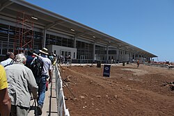
The airport became the world's first "green" airport in December 2012.
The new terminal, which consists of recycled steel tubes taken from oil drilling operations in the Amazon, is spread over 6,000 square meters and required an investment of just over $24 million. The new complex will use clean, renewable technologies such as solar energy, wind farms, and seawater desalination, among other environmental innovations.
According to ECOGAL, the company that operates the terminal, construction of the new airport took into account the surrounding environment and sought to make a minimal impact on the ecosystem. The project was announced in 2008, with construction commencing in 2012. The purpose of the redevelopment from the outset was to create the world's first ecological airport. ECOGAL was awarded a 15-year concession to administer and operate the airport.
The Galapagos non-directional beacon (Ident: GLS) is located 1.0 nautical mile (1.9 km) off the approach threshold of Runway 14. The Galapagos VOR-DME (Ident: GLV) is located on the field.[4][5]
History[]
During World War II, the airport (known as Seymour Island Airfield) was used by the United States Army Air Forces Sixth Air Force defending the South American coastline and the Panama Canal against Japanese submarines. The first American personnel arrived on 9 April 1942. Military flying units assigned to the airport were:
- 52d Fighter Squadron (32d Fighter Group), 5 June-1 December 1942 (P-40 Warhawk)
- 51st Fighter Squadron (32d Fighter Group, later XXVI Fighter Command) 9 December 1942 – 4 March 1944 (P-40 Warhawk)
- Detachments stationed at: Salinas Afld, Ecuador and Talara Afld, Peru, December 1942-March 1943
- 3d Bombardment Squadron (6th Bombardment Group) 4 May 1942 – 12 March 1943 (LB-30 (B-24A) Liberator)
- 29th Bombardment Squadron (6th Bombardment Group) 13 May 1943 – 10 April 1944; 26 April–October 1945 (B-24 Liberator)
- 45th Bombardment Squadron (40th Bombardment Group) 18 February-22 May 1943 (LB-30 (B-24A) Liberator)
- 74th Bombardment Squadron (VI Bomber Command) 21 August 1944 – 13 February 1945 (B-24 Liberator)
- 397th Bombardment Squadron (VI Bomber Command) 7 April 1944 – 6 February 1945 (B-24 Liberator)
By 30 September 1945, most personnel were withdrawn and only a housekeeping staff remained. The military facility was deactivated on 30 April 1946, leaving a communications unit which deactivated on 29 February 1948. Today many of the former USAAF aircraft parking hardstands still exist, along with an unused NW/SE runway that was abandoned after the war, but remains in reasonable condition.
Airlines and destinations[]
| Airlines | Destinations |
|---|---|
| Aeroregional | Guayaquil, Quito |
| Avianca Ecuador | Guayaquil, Quito |
| Equair | Guayaquil, Quito |
| LATAM Ecuador | Guayaquil, Quito |
Statistics[]
| Rank | City | Passengers | Top carriers |
|---|---|---|---|
| 1 | 291,765 | Avianca Ecuador, LATAM Ecuador, Aeroregional | |
| 2 | 229,034 | Avianca Ecuador, LATAM Ecuador, Aeroregional |
See also[]
References[]
![]() This article incorporates public domain material from the Air Force Historical Research Agency website http://www.afhra.af.mil/.
This article incorporates public domain material from the Air Force Historical Research Agency website http://www.afhra.af.mil/.
External links[]
| Wikimedia Commons has media related to Seymour Airport. |
- OpenStreetMap - Seymour
- OurAirports - Seymour
- SkyVector - Baltra
- FallingRain - Seymour Airport
- Current weather for SEGS at NOAA/NWS
- Accident history for Seymour at Aviation Safety Network
Previously: Panama Canal Air Force (1940-1941); Caribbean Air Force (1941-1942) | |||||||||||||||
| Airfields |
|  | |||||||||||||
| Units |
| ||||||||||||||
- Airports in Ecuador
- Airfields of the United States Army Air Forces
- Buildings and structures in Galápagos Province