Shag Point / Matakaea
Shag Point / Matakaea[1] is a headland and township in East Otago, New Zealand.
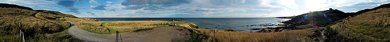
It is located close to State Highway 1 nine kilometres to the northeast of Palmerston, at the southern end of a long open bay known as Katiki Beach. The point itself is a hilly promontory between Katiki Beach and the mouth of the Shag River. Both the river and point take their English name from the shag, a species of cormorant.
A historic Māori site, the Matakaea/Shag Point Occupation Site, is located close to the headland. It is listed as a Category II site by Heritage New Zealand.[2]
Geologically, the area is an exemplar of the Katiki Formation, and the site of the discovery of the plesiosaur Kaiwhekea katiki.
References[]
- ^ https://www.legislation.govt.nz/act/public/1998/0097/latest/DLM431335.html
- ^ "Matakaea/Shag Point Occupation Site". Register of Historic Places. Heritage New Zealand.
Coordinates: 45°27′40″S 170°48′50″E / 45.46111°S 170.81389°E

This Otago geography article is a stub. You can help Wikipedia by . |
- Headlands of Otago
- Populated places in Otago
- NZHPT Category II listings in Otago
- Otago geography stubs