Shakopee Historic District
Shakopee Historic District | |
 | |
| Location | State Highway 101, Shakopee, Minnesota |
|---|---|
| Coordinates | 44°48′27″N 93°29′34″W / 44.80750°N 93.49278°WCoordinates: 44°48′27″N 93°29′34″W / 44.80750°N 93.49278°W |
| Built | 1844 |
| Architect | Multiple |
| MPS | Scott County MRA (AD) |
| NRHP reference No. | 72000682[1] |
| Added to NRHP | April 11, 1972 |


The Shakopee Historic District is a Registered Historic District in Shakopee, Minnesota that includes significant historical artifacts from pre-contact Native American cultures, pre- and post-contact villages of Dakotah people, and early white settlers. The earliest sign of habitation are burial mounds, while the most recent include a gristmill, inn ruins, and ferry landing.[2]
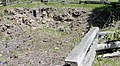
Ruins of Murphy's Inn

unrestored gristmill

Site of Murphy's Landing

Prehistoric burial mounds

National Youth Administration overlook


References[]
- ^ "National Register Information System". National Register of Historic Places. National Park Service. January 23, 2007.
- ^ Nord, Mary Ann (2003). The National Register of Historic Places in Minnesota. Minnesota Historical Society. ISBN 0-87351-448-3.
| Topics | |
|---|---|
| Lists by state |
|
| Lists by insular areas | |
| Lists by associated state | |
| Other areas | |
| Related | |
| |
This article about a property in Minnesota on the National Register of Historic Places is a stub. You can help Wikipedia by . |
Categories:
- Mounds in Minnesota
- Native American history of Minnesota
- Archaeological sites on the National Register of Historic Places in Minnesota
- Buildings and structures in Scott County, Minnesota
- Historic districts on the National Register of Historic Places in Minnesota
- National Register of Historic Places in Scott County, Minnesota
- Minnesota Registered Historic Place stubs