Sham Chun River
Coordinates: 22°30′N 114°02′E / 22.500°N 114.033°E

This article includes a list of references, related reading or external links, but its sources remain unclear because it lacks inline citations. (August 2019) |
| Sham Chun River | |||
|---|---|---|---|
| Chinese | 深圳河 | ||
| |||
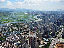
The Sham Chun, Shum Chum River, or Shenzhen River (Chinese: 深圳河; pinyin: Shēnzhèn Hé) serves as the natural border between Hong Kong and Mainland China, together with the Sha Tau Kok River and Deep Bay.

It formed part of the limit of the lease of the New Territories in 1898 in the Convention for the Extension of Hong Kong Territory (also Second Convention of Peking).
It separates Yuen Long District, North District of Hong Kong, and the city of Shenzhen, Guangdong. Its source is at Wutong Mountain, Shenzhen. Its tributaries includes Ping Yuen River, Shek Sheung River, Sheung Yue River, Ng Tung River, Buji River and Tan Shan River. The Shenzhen Reservoir also flows into the river when it is full.
The river flows into Deep Bay (also known as Hau Hoi Wan and Shenzhen Bay). The Mai Po Marshes is at its estuary.
Efforts have been made to alleviate flooding and pollution problems through river training, which produced the Lok Ma Chau Loop.
See also[]
- Frontier Closed Area – the closed border zone on the Hong Kong side of the river
- List of rivers and nullahs in Hong Kong
External links[]
| Wikimedia Commons has media related to Shenzhen River. |
- Rivers of Hong Kong, in Chinese
| Authority control |
|
|---|
This article related to a river in China is a stub. You can help Wikipedia by . |
This Shenzhen-related article is a stub. You can help Wikipedia by . |
- Rivers of Hong Kong
- Rivers of Shenzhen
- North District, Hong Kong
- Borders of Hong Kong
- Border rivers
- Geography of Shenzhen
- China river stubs
- Asia river stubs
- Hong Kong geography stubs
- Shenzhen stubs