Shapurgala
| Shapurgala | |
|---|---|
Azerbaijani: Şapurqala | |
 Location within Azerbaijan | |
| General information | |
| Type | Fortress |
| Location | Kyulyus village |
| Town or city | Shahbuz, Nakhchivan Autonomous Republic |
| Country | Azerbaijan |
| Coordinates | 39°21′35″N 45°39′43″E / 39.359618°N 45.661883°ECoordinates: 39°21′35″N 45°39′43″E / 39.359618°N 45.661883°E |
| Completed | I-X centuries |
| Technical details | |
| Material | Brick |

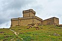
Shapurgala (Azerbaijani: Şapurqala) is a fortress located on the left bank of Nakhchivanay, near the village with the same name in Shahbuz District of Nakhchivan Autonomous Republic.
Research[]
The fortress is located on a high mountain, surrounded by steep cliffs. It was registered as an archeological monument in 1990. The area of the fortress is 1,300 m2. There is a Pir on the road to the fortress. In the area above the Pir, remains of a destroyed construction and pink colored clay dish fragments were encountered.[1]
In the central part of the fortress researchers came across construction remnants, baked bricks, pink clay plates and remains of grain stones and fireplaces.[1] The findings indicate that life in Shapurgala lasted from the first century AD to the XV-XVI centuries.[2] It was also used as a guard station for defensive purposes.[1]
Architectural features[]
The fortress is located in a polygonal-shaped area. The tallest place of the pitch is the tallest cliff in the south-east. Inside the cliff a rectangular room is drilled with 4x3.6 m of area. The burnt bricks of the size of 19x19x5 cm were found inside the room, a rhomb shaped niche was made on the wall of the fortress, and the wall under the niche was made in semi-circular form.[1]
See also[]
References[]
- Castles and fortresses in Azerbaijan
- Monuments and memorials in Azerbaijan
- Tourist attractions in Azerbaijan