Shepetivka Raion
Shepetivka Raion
Шепетівський район | |
|---|---|
Raion | |
 Flag  Coat of arms | |
 | |
| Coordinates: 50°08′06″N 27°10′25″E / 50.13500°N 27.17361°ECoordinates: 50°08′06″N 27°10′25″E / 50.13500°N 27.17361°E | |
| Country | |
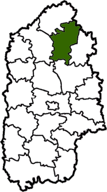
| Region | Khmelnytskyi Oblast |
| Established | 1923 |
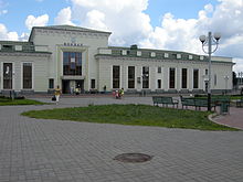
| Admin. center | Shepetivka |
| Subdivisions | 18 hromadas |
| Government | |
| • Governor | Mykola S. Kovalchuk |
| Area | |
| • Total | 1,160 km2 (450 sq mi) |
| Population (2021)[1] | |
| • Total | 280,403 |
| • Density | 240/km2 (630/sq mi) |
| Time zone | UTC+02:00 (EET) |
| • Summer (DST) | UTC+03:00 (EEST) |
| Postal index | 30410—30457 |
| Area code | 380-3840 |
| Website | www |

Shepetivka Raion (Ukrainian: Шепетівський район) is a raion in Khmelnytskyi Oblast in Ukraine. Its administrative center is Shepetivka. Its population is 280,403 (2021 est.)[1]
On 18 July 2020, as part of the administrative reform of Ukraine, the number of raions of Khmelnytskyi Oblast was reduced to three, and the area of Shepetivka Raion was significantly expanded. Four abolished raions, Bilohiria, Iziaslav, Polonne, and Slavuta Raions, as well as the cities of Netishyn, Slavuta, and Shepetivka, which were previously incorporated as a cities of oblast significance and did not belong to the raion, were merged into Shepetivka Raion.[2][3] The January 2020 estimate of the raion population was 32,100 (2020 est.)[4]
It was established in 1923. 1 urban-type settlement (Hrytsiv) and 68 villages were located in Shepetivka Raion until 2020.
Geography[]
This article needs to be updated. (February 2021) |
Shepetivka Region is a part of Volhynia. It is one out 20 Raions of Khmelnytskyi Oblast. It is a large Raion and ranks as the 8th among the largest with respect to the total area (1 160 km² corresponding to 5.6% of the total area of Khmelnytskyi Oblast).
Shepetivka Raion is southeast of Slavuta Raion, southwest of Zhytomyr Oblast (Baranivka Raion), west of Polonne Raion, north of Starokostiantyniv Raion, and east of Iziaslav Raion. The , , , and other rivers flow through the district. There are rail lines through the districts (Shepetivka—Slavuta—Zdolbuniv), Shepetivka—Iziaslav—Ternopil, Shepetivka—Starokostiantyniv, Shepetivka—Polonne and Shepetivka—Novohrad-Volynskyi.
Subdivisions[]
Before 2020[]
Before the 2020 reform, the raion consisted of four hromadas:[5]
- with the administration in the urban-type settlement of Hrytsiv;
- with the administration in the selo of ;
- with the administration in the selo of ;
- with the administration in the selo of Sudylkiv.
After 2020[]
After the reform in July 2020, the raion consisted of 18 hromadas:[3]
- with the administration in the selo of Berezdiv, transferred from Slavuta Raion;[6]
- with the administration in the urban-type settlement of Bilohiria, transferred from Bilohiria Raion;[7]
- with the administration in the selo of Hannopil, transferred from Slavuta Raion;[6]
- with the administration in the urban-type settlement of Hrytsiv, retained from Shepetivka Raion;
- with the administration in the city of Iziaslav, transferred from Iziaslav Raion;[8]
- with the administration in the selo of , transferred from Slavuta Raion;[6]
- with the administration in the selo of , retained from Shepetivka Raion;
- with the administration in the selo of , retained from Shepetivka Raion;
- with the administration in the city of Netishyn, transferred from the city of oblast significance of Netishyn;[9]
- with the administration in the selo of Pluzhne, transferred from Iziaslav Raion;[8]
- with the administration in the city of Polonne, transferred from Polonne Raion;[10]
- with the administration in the urban-type settlement of Poninka, transferred from Polonne Raion;[10]
- with the administration in the selo of , transferred from Iziaslav Raion;[8]
- with the administration in the city of Shepetivka, transferred from the city of oblast significance of Shepetivka;[11]
- with the administration in the city of Slavuta, transferred from the city of oblast significance of Slavuta;[12]
- with the administration in the selo of Sudylkiv, retained from Shepetivka Raion;
- with the administration in the selo of , transferred from Slavuta Raion;[6]
- with the administration in the urban-type settlement of Yampil, transferred from Bilohiria Raion.[7]
History[]
From 1923 to 1932, the district was part of the Shepetivka region, then from 1932 to 1937 it was part of the Vinnytsia region. Following that from 1937 to 1954 it was part of the Kamenets Podolsk region. Since 1954 it has been part of the Khmelnytskyi Oblast.[13]
References[]
- ^ a b "Чисельність наявного населення України (Actual population of Ukraine)" (PDF) (in Ukrainian). State Statistics Service of Ukraine. Retrieved 11 July 2021.
- ^ "Про утворення та ліквідацію районів. Постанова Верховної Ради України № 807-ІХ". Голос України (in Ukrainian). 2020-07-18. Retrieved 2020-10-03.
- ^ a b "Нові райони: карти + склад" (in Ukrainian). Міністерство розвитку громад та територій України.
- ^ "Чисельність наявного населення України (Actual population of Ukraine)" (PDF) (in Ukrainian). State Statistics Service of Ukraine. Retrieved 30 September 2020.
- ^ "Шепетівська районна рада (состав до 2020 г.)" (in Russian). Портал об'єднаних громад України.
- ^ a b c d "Славутська районна рада (состав до 2020 г.)" (in Russian). Портал об'єднаних громад України.
- ^ a b "Білогірська районна рада (состав до 2020 г.)" (in Russian). Портал об'єднаних громад України.
- ^ a b c "Ізяславська районна рада (состав до 2020 г.)" (in Russian). Портал об'єднаних громад України.
- ^ "Нетишинская городская громада" (in Russian). Портал об'єднаних громад України.
- ^ a b "Полонська районна рада (состав до 2020 г.)" (in Russian). Портал об'єднаних громад України.
- ^ "Шепетовская городская громада" (in Russian). Портал об'єднаних громад України.
- ^ "Славутская городская громада" (in Russian). Портал об'єднаних громад України.
- ^ Адміністративно-територіяльний поділ Заславщини наприкінці XVIII – початку ХХІ ст. (in Ukrainian)
External links[]
- www.sheprda.ho.ua (in Ukrainian)
- Хмельницька обласна рада. Passport Shepetivka Raion (doc) (in Ukrainian)
 Media related to Shepetivskyi Raion at Wikimedia Commons
Administrative geographic location | |
|---|---|
- Raions of Khmelnytskyi Oblast
- States and territories established in 1923
- 1923 establishments in Ukraine