Sherrell Point
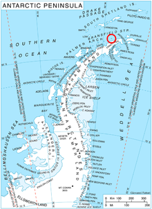
Sherrell Point (63°18′S 58°41′W / 63.300°S 58.683°WCoordinates: 63°18′S 58°41′W / 63.300°S 58.683°W) is a point at the south end of Astrolabe Island, off Trinity Peninsula in Antarctica. It is situated 1.15 km southeast of Gega Point, 4.5 km southeast of Raduil Point and 2.28 km southwest of Rogach Peak. Following air photography and ground survey by FIDASE, 1956–57, the feature was named for Frederick W. Sherrell, surveyor and geologist in this area with FIDASE, 1955–56.
 WikiMiniAtlas
Maps[]
- Trinity Peninsula. Scale 1:250000 topographic map No. 5697. Institut für Angewandte Geodäsie and British Antarctic Survey, 1996.
- Antarctic Digital Database (ADD). Scale 1:250000 topographic map of Antarctica. Scientific Committee on Antarctic Research (SCAR). Since 1993, regularly upgraded and updated.
References[]
- Sherrell Point. SCAR Composite Antarctic Gazetteer.
![]() This article incorporates public domain material from the United States Geological Survey document: "Sherrell Point". (content from the Geographic Names Information System)
This article incorporates public domain material from the United States Geological Survey document: "Sherrell Point". (content from the Geographic Names Information System) ![]()
This Trinity Peninsula, Antarctica, location article is a stub. You can help Wikipedia by . |
- Headlands of Trinity Peninsula
- Astrolabe Island
- Trinity Peninsula geography stubs