Shockoe Hill African Burying Ground
Coordinates: 37°33′06.5″N 77°25′42.2″W / 37.551806°N 77.428389°W


The Shockoe Hill African Burying Ground (Richmond's 2nd African Burial Ground) was established by the city of Richmond, Virginia, for the interment of free people of color, and the enslaved. The heart of this now invisible burying ground is located at 1305 N 5th St. It was created as the replacement for the Burial Ground for Negroes, now also called the African Burial Ground, located in Shockoe Bottom (known historically as Shockoe Valley). The Burial Ground for Negroes was closed in 1816 upon the opening of this new African Burying Ground on Shockoe Hill.

History[]
Establishment[]
The Shockoe Hill African Burying Ground was established in 1816.[1][2] It was a segregated part of the Shockoe Hill Burying Ground, also known as the Shockoe Hill Cemetery, a municipal burying ground owned and operated by the City of Richmond. It was managed by the Superintendent of the Shockoe Hill Burying Ground, who was also the Superintendent of the Poorhouse (with the exception of the years 1863-1867 during which time the positions were separated) and the City Hospital[3][4] The Poorhouse was also called the Almshouse. The burial ground was overseen by the Shockoe Hill Burying Ground Committee, which was a standing committee of the Richmond City Council. The African Burying Ground was active from its opening in February of 1816 until its closure by the city due to overcrowded conditions in June of 1879. The land that comprises this long unacknowledged burial ground, contains nothing on its surface that would cause it to be visibly recognizable as a cemetery today. Its original two one acre plots are located at the northeastern corner of 5th and Hospital St., across the road from the Hebrew Cemetery. It was greatly increased in size over time, expanding in every direction. By 1850 its grounds encompassed as many as 15 acres. Later maps indicate an even greater expansion, to slightly over 31 acres.
Maps[]
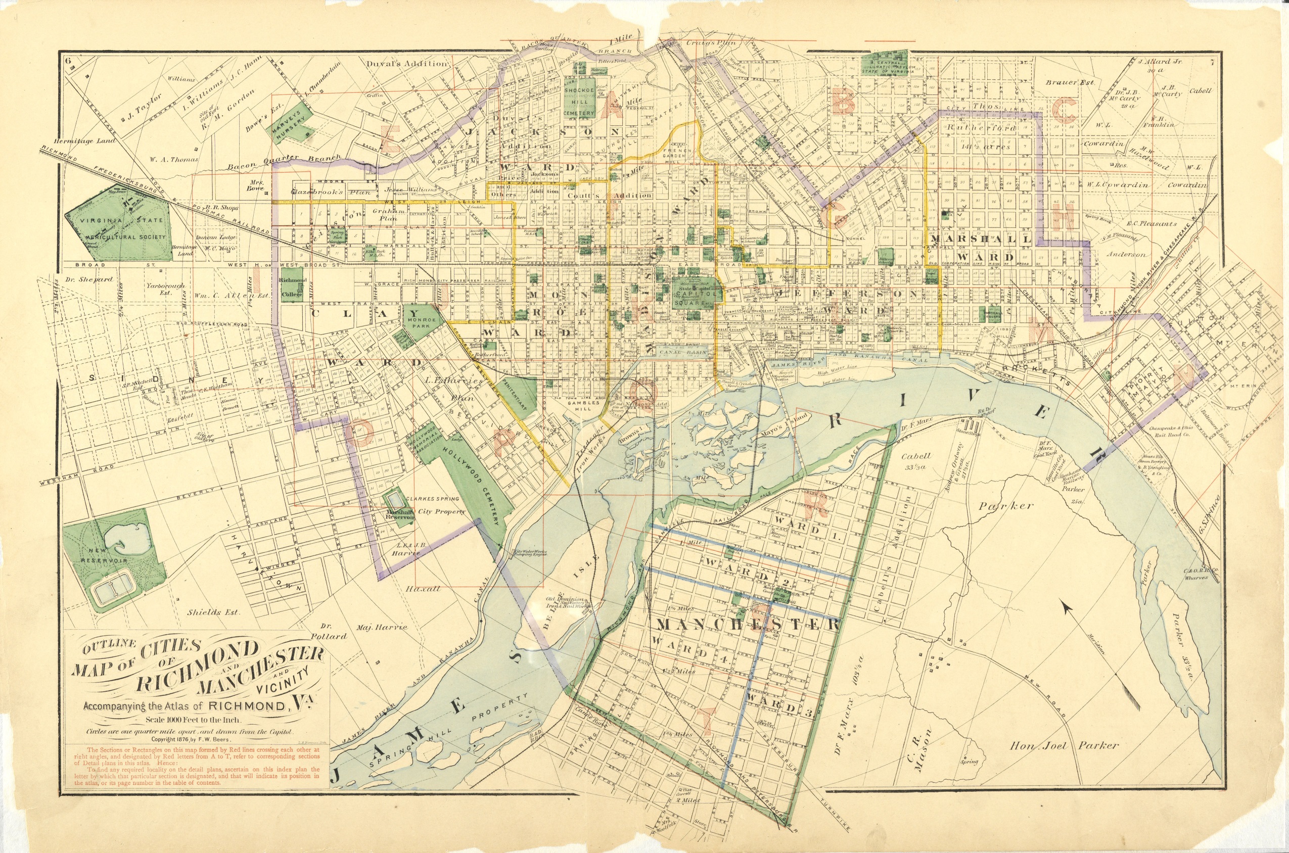
In the 1870s it came to be labeled on maps as Potter's Field, until it last appeared in 1905.[5][6] The 1905 map showed that it extended west behind The Almshouse to 2nd St, and north to the Bacon's Quarter Branch.[7] Some maps show it extending to the east almost as far as 8th St. Earlier maps show it by various names. On the 1816 Plan of the City of Richmond Property, the two one-acre plots were labeled "Burying Ground for Free People of Colour", and the "Burying Ground for Negroes".[2] On the 1817 Map of the City of Richmond, it appears as the "Free People of Colour's B.G." and "Negro(e's) B.G.".[8] The 1835 Plan of the City of Richmond has it recorded as the "Grave Yard for Free People of Colour" and "For Slaves".[9] On that map the burying ground for slaves had been increased by about 1.3 additional acres. The 1842 Bates Map depicts it as "The Burying Ground for Coloured Persons" and "the Burying Ground for Slaves".[10] On the 1849 Plan of Richmond, it is referred to as one place, and was called the "Burying-ground for Coloured Persons".[11] In 1850 the Common Council increased the burying-ground for colored persons by 9 acres in addition to the grounds of the City Hospital.[12] On the 1853 Smith's Map of Henrico County, Virginia, it appears twice. On the county portion of the map it appears under the "Shockoe Hill Burying Ground". On the separate city of Richmond portion of the map it appears as the "African Burying Ground".[13] On the 1856 Map of the city of Richmond, Henrico County, the entire burying ground (black and white) appears under one name, without the additional labels showing its segregated status. Though still segregated, it appears simply as the "Shockoe Hill Burying Ground".[14] This is also the name under which it appears in the majority of records, such as interment reports.[15][16] It is also true for some maps from the 1860s.[17] However; it is from the combination of the two names under which it appears on the 1853 Map that the name "Shockoe Hill African Burying Ground" was derived.
City Hospital grounds[]
During the Civil War, the bodies of more than 500 deceased Union Army Prisoners of War were interred in the Shockoe Hill African Burying Ground. Shortly after the war their remains were removed from the African Burying Ground and then re-interred in the Richmond National Cemetery. The majority of the soldiers had been buried to the north, and to the east of the City Hospital (for smallpox). Interments were also made in the vicinity of the Poorhouse. It was reported that 428 soldiers were removed from the City Hospital, and 128 from the vicinity of the Poorhouse.[18][19][20] The City Hospital building was converted into the Colored Almshouse, which then opened its doors in April of 1868.[21] The City Hospital was included on the 1842 Bates Map, and may have been constructed about that time. It was located directly to the east of the walled Shockoe Hill Cemetery. Its grounds were added to the African Burying Ground by the City Council in 1850. The 1816 plan of the city property shows that the northern grounds of the hospital were already in use for the interment of paupers who had died at the Poorhouse, both black and white.
Desecrations[]
This burying ground has suffered many atrocities. Throughout its years of operation, it was a main target for body snatching by and for the medical colleges, especially the Medical College of Virginia and the University of Virginia.[22][23][24] It suffered from the explosion of a gun powder magazine on April 3, 1865, and the later construction of 2 new powder magazines built upon it in 1867. Its grounds were disposed of by the city of Richmond. Portions of it became part of the Hebrew Cemetery. In addition, it has had roads, a railway, and the highway run through it. An old Sunoco gas station sits upon a portion of its original 2 acres, along with a billboard; while other parts lie beneath Interstate-64, 4th St., 5th St., Hospital St. and also the railroad tracks. The list of abuses does not stop there, and the site remains threatened to this day. Two approaching threats to the burial ground are DC2RVA passenger rail (high-speed rail), and the proposed widening of I-64.[25][26][27] Both transportation projects will directly impact the Shockoe Hill African Burying Ground.
Estimations[]
Reports of interments were regularly made and submitted to Richmond City Council by the Superintendent of the Shockoe Hill Burying Ground. It is estimated that over 22,000 interments were made in the Shockoe Hill African Burying Ground, likely making it the largest burial ground of free people of color and the enslaved in the United States. It is presently referred to by some as the 2nd African Burial Ground or second African Burying Ground,[12][28] and African Burial Ground II.
Developments[]
Recent advocacy led by a descendant of people interred at the Shockoe Hill African Burying Ground, resulted in gaining the support of the city of Richmond.[29][30] In 2020, Mayor Levar Stoney and his administration sponsored two important ordinances regarding the burial ground.[31] Ordinance #2020-213 added the property at 1305 N 5th St. to the Richmond Slave Trail, and provided for the funding of its intended acquisition. Ordinance #2020-240 paved the way for the purchase of the property. Both ordinances were presented before the Richmond City Council who passed them with unanimous support. Though 1305 N. 5th St. is only a small portion of the Shockoe Hill African Burying Ground, it is a significant part. It is 1.2 acres of the original 2 acre 1816 burial ground. More specifically, it is roughly 0.80 acres of the "Burying Ground for Free People of Colour", and about 0.40 acres of the "Burying Ground for Negroes" (enslaved). On February 17, 2021 the city of Richmond successfully bid on 1305 N. 5th St. at a property tax sale. On April 16, 2021 the acquisition of 1305 N. 5th St. was completed.[32]
Other developments:
September 17, 2020 - a Preliminary Information Form (P.I.F.) was presented before the Virginia State Review Board, seeking approval to write the nomination for the Shockoe Hill Burying Ground Historic District for listing in the Virginia Landmarks Register (VLR) and the National Register of Historic Places (NRHP). The P.I.F received the board's unanimous approval, making the historic district eligible for nomination.
May 11, 2021 - Preservation Virginia, named the Shockoe Hill African Burying Ground, one of Virginia's Most Endangered Historic Places.[33]
June 17, 2021 - a proposal was presented to the Virginia Board of Historic Resources for an Historical Highway Marker for the Shockoe Hill African Burying Ground. It was unanimously approved.[34][35]
July 2,2021 - the CSX right-of-way over the Shockoe Hill African Burying Ground was divided, and the northern half and eastern half were transferred to Virginia Passenger Rail Authority (VPRA).
July 28, 2021 - the completed nomination for the Shockoe Hill Burying Ground Historic District was submitted to the Virginia Department of Historic Resources (DHR), seeking inclusion in the Virginia Landmarks Register (VR) and the National Register of Historic Places (NRHP). The Shockoe Hill African Burying Ground is a part of the historic district.[36]
September 2, 2021 - The Society For American Archaeology publicly published its letter of support for the Shockoe Hill Burying Ground Historic District's nomination to the National Register of Historic Places.
October 20, 2021 - at the CTB Rail and Transit Subcommittee Meeting, it was announced by the Chair Jennifer Mitchell that the DC2RVA, Section 106 Process: Federal Railroad Administration (FRA) was reopening the National Historic Preservation Act Section 106 consultation process for the DC to Richmond High Speed Rail (DC2RVA). This was due in part to the presence of a "new National Register of Historic Places (NRHP) eligible resources in the area of potential effects (APE), the Shockoe Hill Burying Ground Historic District (127-7231), and one resource with expanded boundaries, the Shockoe Hill African Burying Ground (44HE1203)."<ref DRAFT MINUTES CTB Rail and Transit Subcommittee Meeting, September 28, 2021</ref>
December 2021 - The Cultural Landscape Foundation featured the Shockoe Hill African Burying Ground in its online exhibition, Landslide 2021: Race and Space. This exhibition features nationally significant cultural landscapes that are associated with African Americans, Hispanic Americans, and Native peoples that are threatened and at-risk.
References[]
- ^ The Richmond Enquirer, February 22, 1816, "This is to inform the Inhabitants of the City of Richmond", Chronicling America, Library of Congress
- ^ a b Young, Richard (1816). "Plan of 28 1/2 Acres of ground where on is situated the Poorhouse of the city of Richmond" city of Richmond.
- ^ The Daily Dispatch, May 19, 1863, "City Council", Chronicling America, Library of Congress
- ^ The Daily Dispatch, June 18, 1867, "Local Matters", Chronicling America, Library of Congress
- ^ Beers, F. W. (1876). "Outline Map of Cities in Richmond and Manchester and Vicinity", Virginia Memory, Library of Virginia.
- ^ Highland Park Company (1891). "Map of the Property of the Highland Park Company showing its location with reference to the City of Richmond", University of Virginia Special Collections.
- ^ Scrivernor, Arthur, T. Crawford Redd & Bro. surveyors and engineers (1905). "Map of Richmond and Surroundings", Valentine Museum.
- ^ Young, Richard (1817). "Map of the city of Richmond and its jurisdiction including Manchester", Library of Virginia.
- ^ Bates, Micajah (1835). "Plan of the City of Richmond Drawn From Actual Survey and Regional Plans". University of Virginia.
- ^ Bates, Micajah (1842). "A Connected Plat of the City Property near the Poor House", City of Richmond
- ^ Morgan, Charles S. (1849). "Plan of Richmond (Henrico County) Manchester & Springhill, Virginia". Library of Virginia – via Google Arts and Culture.
- ^ a b Smith, Ryan K. "Shockoe Hill African Burying Ground". Richmond Cemeteries.
- ^ Smith, Robert Pearsall (1853). "Smith's map of Henrico County, Virginia from actual surveys by James Keily". Library of Virginia.
- ^ Map of the city of Richmond, Henrico County (1856). [1], by William Slides, Google Arts & Culture, original source Library of Virginia.
- ^ Interments, The Daily Dispatch, January 10, 1855, Chronicling America, Library of Congress
- ^ Bill of Mortality, The Daily Dispatch, May 9, 1856, Chronicling America, Library of Congress
- ^ United States Coast Survey. (1864) Map of the city of Richmond, Virginia. [Washington, D.C., U.S. Coast Survey] [Map] Retrieved from the Library of Congress.
- ^ "Roll of honor: names of soldiers who died in defense of the American union, interred in the national [and other] cemeteries" by United States, Quartermaster's Dept (1865) Published by, Government Printing Office, Washington DC
- ^ Philadelphia Inquirer, April 11, 1865 "From Another Correspondent"
- ^ "Statement of the Disposition of Some of the Bodies of Deceased Union Soldiers and Prisoners of War Whose Remains Have Been Removed to National Cemeteries in the Southern and Western States: Volumes 1-4" United States. Army. Quartermaster's Department, (Jan 1868) Published by, U.S. Government Printing Office, Washington, DC
- ^ The Daily Dispatch, March 17, 1869 "Almshouse Report", Chronicling America, Library of Congress
- ^ McInnis, Maurie D. and Nelson, Louis P. (Edited by) Educated in Tyranny: Slavery at Thomas Jefferson's University, University of Virginia Press Charlottesville and London (2019).
- ^ Berry, Daina Ramey The Price for Their Pound of Flesh: The Value of the Enslaved, from Womb to Grave, in the Building of a Nation, Beacon Press, Boston (2017).
- ^ Koste, Jodi L., "Artifacts and Commingled Skeletal Remains from a Well on the Medical College of Virginia Campus: Anatomical and Surgical Training in Nineteenth-Century Richmond", Virginia Commonwealth University Archives.
- ^ Smith, Ryan K. "Disappearing The Enslaved: The Destruction and Recovery of Richmond's Second African Burial Ground", Buildings & Landscapes: Journal of the Vernacular Architecture Forum Vol. 27, No. 1 (Spring 2020), pp. 17-45, University of Minnesota Press.
- ^ Yeager, Jordy. "Passenger Rail Project Slated To Run Through Richmond African American Graveyard", (July 25, 2019) npr news.
- ^ Lazarus, Jeremy M.,"Historic site review slows rail lines planned over historic Black cemetery"(April 22, 2021), Richmond Free Press
- ^ Smith, Ryan K. Death and Rebirth in a Southern City: Richmond's Historic Cemeteries, Johns Hopkins University Press (November 17, 2020), John Hopkins.
- ^ Richmond Free Press, March 6, 2020, "One woman's crusade brings attention to long-forgotten black cemetery" Lazarus, Jeremy M
- ^ Style Weekly, October 20, 2020, OPINION: "Honoring Ancestors - The city should support the acquisition of 1305 N. Fifth St. and its inclusion on the Slave Trail." Lenora McQueen
- ^ "Stoney Introduces Ordinance To Amend Scope Of Devil's Half Acre Project, Acquire Part Of Burial Ground For Free People Of Colour And Slaves", (October 1, 2020) Patch Media
- ^ Richmond Times Dispatch, April 19, 2021, memorializing a site in shockoe hill, "Richmond buys back historical Black burial grounds on Shockoe Hill", Richmond.com
- ^ Richmond Times Dispatch, May 21, 2021, "No sign commemorates a place in Richmond where 20,000 Black people were buried. Lenora McQueen wants to change that." Richmond.com
- ^ Richmond Times Dispatch, June 17, 2021, "Highway marker approved for Shockoe Hill African Burial Ground by state agency", Richmond.com
- ^ Richmond Free Press, June 24, 2021, "History marker to be placed at Shockoe Hill African Burying Ground"
- ^ Smith, Ryan K. "Approaching the National Register – Shockoe Hill". Richmond Cemeteries.
External links[]
- Richmond Cemeteries, Shockoe Hill African Burying Ground
- Sacred Ground Historical Reclamation Project: Shockoe Hill African Burial Ground
- Wikimapia, Shockoe Hill African Burying Ground
- Virginia Department of Historic Resources, PRELIMINARY INFORMATION FORM (PIF) for HISTORIC DISTRICTS, "Shockoe Hill Burying Ground" (127-7231)
- The Black Cemetery Network
- Preservation Virginia - Virginia’s Most Endangered Historic Places List 2021
- African American Heritage Sites: African American Endangered Historic Sites Places - Shockoe Hill African Burying Ground
- Richmond Cemeteries, Approaching the National Register - Shockoe Hill
- Sacred Spaces: Preserving African American Cemeteries
- Dead Reckoning: The Historical Recovery and Unsettled Place of Richmond's Shockoe Hill African Burying Ground - The 2021 Elske v.P. Smith Lecture featuring Ryan K. Smith, Professor in the Department of History
- Landslide 2021: Race and Space: Hidden Histories Revealed,THE CULTURAL LANDSCAPE FOUNDATION, Shockoe Hill African Burying Ground
- Feature Stories, THE CULTURAL LANDSCAPE FOUNDATION: National Attention for Shockoe Hill African Burying Ground
- Cemeteries in Richmond, Virginia
- African-American cemeteries
- African-American history in Richmond, Virginia
- History of slavery in Virginia
- African-American history