Shokalsky Strait
| Shokalsky Strait | |
|---|---|
 Icebergs at the eastern end of the Shokalsky Strait off the northern end of Bolshevik Island | |
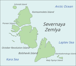 Map showing the location of Shokalsky Strait | |
 Shokalsky Strait | |
| Location | Arctic, Krasnoyarsk Krai |
| Coordinates | 78°48′N 100°04′E / 78.800°N 100.067°ECoordinates: 78°48′N 100°04′E / 78.800°N 100.067°E |
| Native name | Пролив Шокальского (Russian) |
| Ocean/sea sources | Kara Sea / Laptev Sea |
| Basin countries | Russia |
| Max. width | 50 km (31 mi) |

Shokalsky Strait (Russian: Пролив Шокальского) is a strait in Severnaya Zemlya, Russia.
Geography[]
The Shokalsky Strait is an up to a 50 km-wide strait that separates Bolshevik Island from October Revolution Island, connecting the Kara Sea in the west with the Laptev Sea in the east.[1] It is named after Russian oceanographer Yuly Shokalsky
Some fjords of Severnaya Zemlya have their mouths in the strait, such as Marat Fjord in October Revolution Island's eastern shore, as well as , and in Bolshevik Island northwestern coast.[2]
Cape Baranov[3] and its adjacent [4] are located in the northern part of Bolshevik Island facing the Shokalsky Strait.[5]
The Krasnoflotskiye Islands are located at the western end of the strait.[5]

See also[]
References[]
- ^ "Proliv Shokal'skogo". Mapcarta. Retrieved 23 November 2016.
- ^ "F'ord Marata". Mapcarta. Retrieved 26 December 2016.
- ^ "Mys Baranova". Mapcarta. Retrieved 26 December 2016.
- ^ Информационное сообщение об открытии «Ледовой базы «Мыс Баранова» для выполнения научных работ ААНИИ в 2013-2014 г.г.
- ^ a b GoogleEarth
This Sakha Republic location article is a stub. You can help Wikipedia by . |
- Straits of Severnaya Zemlya
- Bodies of water of the Sakha Republic
- Straits of the Laptev Sea
- Straits of the Kara Sea
- Sakha Republic geography stubs