Shotley
| Shotley | |
|---|---|
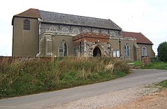 St Mary's Church | |
 Shotley Location within Suffolk | |
| Area | 8.13 km2 (3.14 sq mi) |
| Population | 2,342 (2011)[1] |
| • Density | 288/km2 (750/sq mi) |
| OS grid reference | TM236351 |
| District | |
| Shire county | |
| Region | |
| Country | England |
| Sovereign state | United Kingdom |
| Post town | Ipswich |
| Postcode district | IP9 |
| Dialling code | 01473 |
| UK Parliament | |
Shotley is a village and civil parish 8 miles (13 km) south-east of Ipswich in the English county of Suffolk. It is in the Babergh district and gives its name to the Shotley peninsula between the Rivers Stour and Orwell. The parish includes the village of Shotley and the settlements of Shotley Gate and Church End. In 2011 civil parish had a population of 2,342.
Shotley[]
The village of Shotley is about a mile northwest from the tip of the peninsula, and lies either side of the B1456 road (the Street). In 2018 it had an estimated population of 854.[2] There are two entries for Shotley (Scoteleia) and an adjacent settlement of Kirkton (Cherchetuna) listed in the Domesday Book of 1086.[3]
A school is located outside the village (half of 1 km east) opposite the turning into Oldhall Road. Oldhall Road is located east of the village leading north to St Mary's Church. The church is adjacent to a large naval cemetery cared for by the Commonwealth War Graves Commission. It has graves from both World Wars, not only those of HMS Ganges trainees, but also of Harwich-based warships killed in action with the Germans. There is a memorial to the dead from the 14-18 Harwich submarines.[4]
Shotley Hall is located near to the church. Rose Farm lies to the south of the village.
Shotley Parish Council holds its main meeting at the village hall at 19.00 hours every third Thursday of every month, while the Open Spaces and Amenities Committee meets most months on the second Thursday. Both are open to the public.
Shotley Gate[]
It has been suggested that this article be split into a new article titled Shotley Gate. (Discuss) (September 2021) |

Shotley Gate is a settlement to the south of the village of Shotley at the tip of the peninsula. In 2018 it had an estimated population of 1473.[5]
By about 800 AD, the Vikings or Danes started to make an appearance in this area. Under the Peace of Wedmore in 878, all land north of the old Roman Watling Street, which ran from London to Chester, was given to the Viking leader, Guthrum. Shotley therefore became part of Danelaw. The peace was short-lived however, and following an unsuccessful Viking attack on Kent, Alfred King of Wessex attacked the enemy in East Anglia. The Anglo-Saxon Chronicle for the year 885 reads as follows: The same year sent King Alfred a fleet from Kent into East Anglia. As soon as they came to Stourmouth, there met them sixteen ships of the pirates, and they fought with them, took all the ships and slew the men. As they returned homeward with their booty, they met a large fleet of pirates and fought with them the same day, but the Danes had the victory. It is possible that Bloody Point at Shotley took its name from this incident, however at that time the river entered the sea north of Felixstowe and so the area would not have been seen as the mouth of the Stour. It could also have derived this name late in the next century when the Vikings returned to the estuary in force, twice plundering Ipswich.[6] Shotley Gate and the parish have a strategic position for protecting the ports of Felixstowe, Harwich and Ipswich and in 1865 the Shotley Battery fortifications were established.
King Edward III camped here early in the Hundred Years War, before the great sea Battle of Sluys. Documents signed by him and kept in the National Archive end with the words "at Shotley".
Shotley Gate also harbours HMS Ganges, a former Royal Navy training establishment (RNTE Shotley) for boys. The teak ship was constructed in 1821 and taken out of service in 1861. It was moved to Shotley in 1899, and by 1905 was moved ashore. A large proportion of the naval ratings of the 20th century, boy entrants in peacetime and men during both World Wars, trained there. The training establishment closed in 1976 and the site was subsequently sold for redevelopment. In June 2011 Babergh District Council declared the site a Conservation Area.[7]
The HMS Ganges Museum (open Saturdays, Sundays and Bank Holidays between Easter and the end of October 1100 to 1700hrs) houses artefacts and memorabilia from the old shore establishment including a large collection of photographs and original documents.[8]
Amenities and places of interest[]
The Rose public house is situated in the village of Shotley. The Bristol Arms public house lies in Shotley Gate near the piers and Martello towers. The Shipwreck public house is located at Shotley Marina,[9] also in Shotley Gate at the end of King Edward VII Drive – a popular tourist destination.
In the summer months a foot and cycle ferry service licensed to carry up to 12 passengers operates between Shotley Marina, Harwich and Felixstowe.[10]
There are a few listed buildings located in Shotley, including Martello towers and the ceremonial mast from the former HMS Ganges.[11] Shotley Cottage (half of 1 km southeast of the village of Shotley) was a World War I radio telegraphy station. The Suffolk Historic Environment Record lists more than 200 sites and monuments in Shotley.[12]
St Mary's Church Walking Club, Shotley, meets on the second Sunday of every month.
HMS Ganges site redevelopment[]

Redevelopment of the former HMS Ganges was first proposed in 2000, with a series of retirement homes planned for the site. The site remains undeveloped and its future is uncertain.[13][14] The site has had planning permission granted in principle.
Notable people[]
Admiral Sir Charles Dare spent his last years in Shotley and died there in 1924.[15]
In popular culture[]
The area features in Arthur Ransome's children's novels of the late 1930s We Didn't Mean to Go to Sea and Secret Water. The character Commander Walker is a naval officer stationed at Shotley. Alan Peck's murder mystery of 2007 The Shotley Incident revolves around the former HMS Ganges site and the village and marina feature in the 2011–2012 Strong Winds trilogy of children's books by Julia Jones.
Scenes in the 1956 British war film Yangtse Incident: The Story of HMS Amethyst were shot off of Shotley Gate and the 2011 TV series A Farmer's Life for Me hosted by Jimmy Doherty was filmed at Hill House farm in the parish.
References[]
- ^ "Civil Parish population 2011". Neighbourhood Statistics. Office for National Statistics. Retrieved 27 August 2016.
- ^ "Shotley". City Population De. Retrieved 11 October 2020.
- ^ "PLACE: SHOTLEY". Open Domesday. Retrieved 16 April 2012.
- ^ "SHOTLEY (ST. MARY) CHURCHYARD". Commonwealth War Graves Commission. Retrieved 23 April 2012.
- ^ "Shotley Gate". City Population De. Retrieved 16 September 2020.
- ^ "885AD Bloody Point". The Harwich Society. Retrieved 16 April 2012.
- ^ "Strategy Committee – 2 June 2011". Babergh District Council. Retrieved 16 April 2012.
- ^ "The HMS Ganges Museum". HMS Ganges Museum. Retrieved 14 April 2012.
- ^ "Shotley Marina". East Coast Marinas. Retrieved 14 April 2012.
- ^ "Harwich Harbour Foot & Cycle Ferry". Harwich Harbour Ferry Services. Retrieved 14 April 2012.
- ^ "Listed Buildings in Shotley, Suffolk". British Listed Buildings. Retrieved 14 April 2012.
- ^ "The Suffolk Historic Environment Record – Shotley". Heritage Gateway. Retrieved 6 May 2012.
- ^ "HMS Ganges development". MyShotley. Archived from the original on 8 April 2012. Retrieved 16 April 2012.
- ^ "Shotley Gate: Plans go in for 285 homes at HMS Ganges – 17 April 2012". East Anglian Daily Times. Retrieved 21 April 2012.
- ^ "National Archives: ADM196/19: Dare, Charles Holcombe". Retrieved 14 January 2019.
External links[]
 Media related to Shotley at Wikimedia Commons
- Shotley Parish Council
- Shotley Gate Conservation Area Appraisal
- Shotley
- Villages in Suffolk
- Civil parishes in Suffolk
- Babergh
- River Orwell