Si Lom MRT station
Si Lom | |||||||||||
|---|---|---|---|---|---|---|---|---|---|---|---|
 Si Lom Station entrance and connection with the Sala Daeng BTS station above | |||||||||||
| Location | Bang Rak and Pathum Wan, Thailand | ||||||||||
| Owned by | Mass Rapid Transit Authority of Thailand (MRTA) | ||||||||||
| Operated by | Bangkok Expressway and Metro Public Company Limited (BEM) | ||||||||||
| Line(s) | MRT MRT Blue Line | ||||||||||
| Platforms | 2 split platform (2 exits, 2 elevators) | ||||||||||
| Connections | BTS BTS Silom Line (Off-station connection) | ||||||||||
| Construction | |||||||||||
| Structure type | Underground | ||||||||||
| Other information | |||||||||||
| Station code | BL26 | ||||||||||
| Website | BMCL Website | ||||||||||
| History | |||||||||||
| Opened | 3 July 2004 | ||||||||||
| Services | |||||||||||
| |||||||||||
Si Lom station (Thai: สถานีสีลม, RTGS: Sathani Si Lom, pronounced [sā.tʰǎː.nīː sǐː lōm]) is an underground station of the Bangkok MRT, on the Blue Line. The station is located beneath Rama IV Road at Sala Daeng Intersection, where Si Lom Road begins, serving one of the city's main business districts.
Station[]
Si Lom station is the 26th station on the Blue Line, lying between the Lumphini and Sam Yan stations on a section of the line running beneath Rama IV Road. It has been described as the most challenging to construct of the Blue Line, since it lies beneath the Thai–Japan Bridge that crosses Sala Daeng Intersection, requiring a complex underpinning process to replace the bridge's original foundations. The station features two vertically stacked platforms beneath the main concourse level, which is deeper than that of other stations to accommodate the bridge foundations. At a depth reaching 30 metres (98 ft), it is the deepest station in the MRT system, and features the longest escalator in Southeast Asia.[1]
Si Lom station is connected to Sala Daeng BTS station by a covered elevated walkway, and forms one of the three original main links between the MRT and BTS systems. The station has two exits: one on the northeast corner of the intersection, near the entrance to Lumphini Park, and the other, which connects to the skywalk, on the south corner in front of the Dusit Thani Hotel.
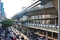
Skywalk linking Si Lom station and Sala Deang Station

References[]
- ^ "MRT ที่สร้างยากสุด ลึกสุด และบันไดเลื่อนยาวสุด..?". Render Thailand (in Thai). 2016-02-27. Retrieved 13 June 2021.
Coordinates: 13°43′45″N 100°32′15″E / 13.7292°N 100.5375°E

This Thai railway station-related article is a stub. You can help Wikipedia by . |
- MRT (Bangkok) stations
- Railway stations opened in 2005
- 2005 establishments in Thailand
- Bangkok stubs
- Thai railway station stubs