Si Prachan District
Si Prachan
ศรีประจันต์ | |
|---|---|
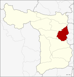
 District location in Suphan Buri Province | |
| Coordinates: 14°37′11″N 100°8′40″E / 14.61972°N 100.14444°ECoordinates: 14°37′11″N 100°8′40″E / 14.61972°N 100.14444°E | |
| Country | Thailand |
| Province | Suphan Buri |
| Subdistricts | 9 |
| Mubans | 64 |
| Area | |
| • Total | 181.0 km2 (69.9 sq mi) |
| Population (2013) | |
| • Total | 62,419 |
| • Density | 359.1/km2 (930/sq mi) |
| Time zone | UTC+7 (ICT) |
| Postal code | 72140 |
| Geocode | 7205 |
Si Prachan District (Thai: ศรีประจันต์, pronounced [sǐː prā.t͡ɕān]) is a district (amphoe) in the eastern part of Suphan Buri Province, central Thailand.
History[]
The government separated some parts of Tha Phi Liang District (now Mueang Suphan Buri) and Sam Chuk District to create Si Prachan District in 1901.
Geography[]
Neighboring districts are (from the south clockwise): Mueang Suphan Buri, Don Chedi and Sam Chuk; and Sawaeng Ha, Pho Thong, Samko and Wiset Chai Chan of Ang Thong Province.
The main water resource of the district is the Tha Chin River.
Administration[]
Central administration[]
Si Prachan is divided into nine subdistricts (tambons), which are further subdivided into 64 administrative villages (mubans).
| No. | Name | Thai | Villages | Pop.[1] |
|---|---|---|---|---|
| 1. | Si Prachan | ศรีประจันต์ | 6 | 8,607 |
| 2. | Ban Krang | บ้านกร่าง | 6 | 8,334 |
| 3. | Mot Daeng | มดแดง | 7 | 5,412 |
| 4. | Bang Ngam | บางงาม | 6 | 3,382 |
| 5. | Don Pru | ดอนปรู | 9 | 9,210 |
| 6. | Plai Na | ปลายนา | 7 | 8,329 |
| 7. | Wang Wa | วังหว้า | 7 | 5,382 |
| 8. | Wang Nam Sap | วังน้ำซับ | 7 | 6,761 |
| 9. | Wang Yang | วังยาง | 9 | 7,002 |
Local administration[]
There are six subdistrict municipalities (thesaban tambons) in the district:
- Ban Krang (Thai: เทศบาลตำบลบ้านกร่าง) consisting of parts of subdistrict Ban Krang.
- Wang Wa (Thai: เทศบาลตำบลวังหว้า) consisting of subdistrict Wang Wa.
- Wang Nam Sap (Thai: เทศบาลตำบลวังน้ำซับ) consisting of subdistrict Wang Nam Sap.
- Si Prachan (Thai: เทศบาลตำบลศรีประจันต์) consisting of parts of subdistricts Si Prachan, Ban Krang.
- Wang Yang (Thai: เทศบาลตำบลวังยาง) consisting of subdistrict Wang Yang.
- Plai Na (Thai: เทศบาลตำบลปลายนา) consisting of subdistrict Plai Na.
There are four subdistrict administrative organizations (SAO) in the district:
- Si Prachan (Thai: องค์การบริหารส่วนตำบลศรีประจันต์) consisting of parts of subdistrict Si Prachan.
- Mot Daeng (Thai: องค์การบริหารส่วนตำบลมดแดง) consisting of subdistrict Mot Daeng.
- Bang Ngam (Thai: องค์การบริหารส่วนตำบลบางงาม) consisting of subdistrict Bang Ngam.
- Don Pru (Thai: องค์การบริหารส่วนตำบลดอนปรู) consisting of subdistrict Don Pru.
References[]
- ^ "Population statistics 2013" (in Thai). Department of Provincial Administration. Retrieved 2014-10-04.
- Amphoe of Suphan Buri Province
- Central Thailand geography stubs
