Siemianice, Pomeranian Voivodeship
Siemianice | |
|---|---|
Village | |
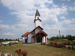 Church in Siemianice | |
 Siemianice | |
| Coordinates: 54°30′1″N 17°3′31″E / 54.50028°N 17.05861°E | |
| Country | |
| Voivodeship | Pomeranian |
| County | Słupsk County |
| Gmina | Gmina Słupsk |
| Elevation | 78 m (256 ft) |
| Population | approximately 2,000 |
| Website | http://www.slupsk.ug.gov.pl/test/siemianice.htm |

| Wikimedia Commons has media related to Siemianice (Pomeranian Voivodeship). |
Siemianice [ɕɛmjaˈnit͡sɛ] (German Schmaatz) is a village in the administrative district of Gmina Słupsk, within Słupsk County, Pomeranian Voivodeship, in northern Poland.[1] It lies approximately 5 kilometres (3 mi) north-east of Słupsk and 104 km (65 mi) west of the regional capital Gdańsk.
Before 1945 the area of Farther Pomerania, where the village is located, was part of Germany.[2][3] On March 8, 1945, the region was captured by the Red Army, and after the end of World War II it became part of Poland. The German inhabitants were expelled. For the history of the region, see History of Pomerania.
The village has a population of approximately 2,000.
References[]
- ^ "Central Statistical Office (GUS) - TERYT (National Register of Territorial Land Apportionment Journal)" (in Polish). 2008-06-01.
- ^ Karl-Heinz Pagel: Der Landkreis Stolp in Pommern. Lübeck 1989, pp. 863-869 (Download Description of village Schmaatz, in German)
- ^ For older notes on the history of the village of Schmaatz see, e. g., Ludwig Wilhelm Brüggemann: Ausführliche Beschreibung des gegenwärtigen Zustandes des Königlich-Preußischen Herzogtums Vor- und Hinterpommern. Part II, Vol 2, Stettin 1784, p. 929, no. 9 and p. 1001, no. 123 (in German)
Coordinates: 54°30′1″N 17°3′31″E / 54.50028°N 17.05861°E
| Authority control |
|
|---|
This Słupsk County location article is a stub. You can help Wikipedia by . |
- Villages in Słupsk County
- Słupsk County geography stubs