Sierpowo, Pomeranian Voivodeship
Sierpowo | |
|---|---|
Village | |
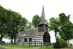 Saint Jude Thaddeus church in Sierpowo | |
 Sierpowo | |
| Coordinates: 53°37′48″N 16°58′42″E / 53.63000°N 16.97833°E | |
| Country | |
| Voivodeship | Pomeranian |
| County | Człuchów |
| Gmina | Czarne |
| Population | 187 |
| Time zone | UTC+1 (CET) |
| • Summer (DST) | UTC+2 (CEST) |

Sierpowo [ɕerˈpɔvɔ] (German: Breitenfelde) is a village in the administrative district of Gmina Czarne, within Człuchów County, Pomeranian Voivodeship, in northern Poland.[1] It lies approximately 7 kilometres (4 mi) south of Czarne, 26 km (16 mi) west of Człuchów, and 136 km (85 mi) south-west of the regional capital Gdańsk. It is located within the historic region of Pomerania.
The village has a population of 187.
Sierpowo was a private village within the Polish Crown, owned by various Polish nobles, administratively located in the Człuchów County in the Pomeranian Voivodeship.[2] During World War II the Germans operated a labor camp for prisoners of war from the Stalag II-B prisoner-of-war camp in the village.[3]
The landmark of Sierpowo is the timber framed Saint Jude Thaddeus church, built in the 17th century.
References[]
- ^ "Central Statistical Office (GUS) - TERYT (National Register of Territorial Land Apportionment Journal)" (in Polish). 2008-06-01.
- ^ Marian Biskup, Andrzej Tomczak, Mapy województwa pomorskiego w drugiej połowie XVI w., Toruń, 1955, p. 87 (in Polish)
- ^ "Les Kommandos". Stalag IIB Hammerstein, Czarne en Pologne (in French). Retrieved 30 April 2020.
| hide | ||
|---|---|---|
| Town and seat |  | |
| Villages | ||
Coordinates: 53°37′48″N 16°58′42″E / 53.63000°N 16.97833°E
This Człuchów County location article is a stub. You can help Wikipedia by . |
- Villages in Człuchów County
- West Prussia
- Posen-West Prussia
- Province of Pomerania (1815–1945)
- Człuchów County geography stubs