Sierra de las Nieves National Park
| Sierra de las Nieves Natural Park | |
|---|---|
| Parque natural de la Sierra de las Nieves | |
IUCN category V (protected landscape/seascape) | |
 | |
| Location | Province of Málaga |
| Nearest city | Tolox |
| Coordinates | 36°41′00″N 05°00′00″W / 36.68333°N 5.00000°WCoordinates: 36°41′00″N 05°00′00″W / 36.68333°N 5.00000°W |
| Area | 93,930 ha (362.7 sq mi) |
| Established | July 28, 1989 |
| Visitors | 100,000 |

The Sierra de las Nieves Natural Park (Spanish: Parque natural de la Sierra de las Nieves) is a natural park in the Sierra de las Nieves range, Andalusia, southern Spain. It is located behind Marbella and to the east of the road to Ronda from the Costa del Sol. In 2019 it was approved to become the sixteenth Spanish national park,[1] the third in Andalusia. On July, 1st, 2021 it was declared National Park.[2]
Description[]
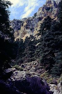
The park centres on La Torrecilla (1,919 m (6,296 ft)), the highest point of the range, and covers an area of 300 km². This mountainous area has a rich variety of flora and fauna. Historically there has been little human influence or agricultural activity in the mountains, which can be snow-covered in the winter, hence their name in Spanish.[3]
The Sierra de las Nieves area was studied in the 19th century by Swiss botanist Pierre Edmond Boissier and in 1933 by Luis Ceballos.
In 1970, a delimited area of the Sierra de las Nieves Range was declared a National Hunting Reserve. On 28 July 1989, it was declared a Natural Park, covering an area of 201.63 km2 (77.85 sq mi).[4] On 15 June 1995, it was declared a Biosphere Reserve by UNESCO, and the park area was expanded to 93,930 hectares (362.7 sq mi), including 11 municipalities.[5][6]
Caves[]
This section does not cite any sources. (December 2020) |
There are a considerable number of large caves in the park, several taking the traditional form of horizontal caverns. Three are of particular interest,[according to whom?] namely , and .
The area is known for its shafts. One of these, , is one of the deepest in Europe and was named after the Grupo de Exploraciones Subterráneas de Málaga (GESM) which explored it in September 1978. The entrance to this shaft is located at 1670 m and descends 1098 m with a few large drops. The drops 115 m and the has a vertical fall of 194 m. At a depth of 900 m there are some interesting rock formations in the , and is located almost at the bottom. It has still[when?] not been fully explored.
is located in the area of the at an altitude of 760 m. It is 54 m deep. It can be reached from Tolox. Many prehistoric artefacts have been recovered from this cave and many are to be found in the Málaga Museum.
Some of the other shafts are mentioned here. The list is by no means exclusive and many are surely yet to be discovered.
- is located at an altitude of 1640 m and drops to a depth of 133 m and is formed from two vertical wells of 52 m and 80 m.
- is located at an altitude of 1600 m, dropping only 22 m.
- is near GESM and drops 7 m.
- is located 500 m from the recreation area and is 10 m deep.
- is located near at 1750 m altitude and drops 38 m.
- , located near , is 103 m deep with various drops, one of which is 53 m.
- located near Hoyos de Pilar is 57 m deep.
- Sima de las Palomas located near Hoyos de Pilar is 56 m deep.
References[]
- ^ "El BOE publica la aprobación de la propuesta de declaración del Parque Nacional de la Sierra de las Nieves". Diario Sur (in Spanish). 8 January 2019. Retrieved 17 July 2020.
- ^ "Ley 9/2021, de 1 de julio, de declaración del Parque Nacional de la Sierra de las Nieves". boe.es (in Spanish). 3 July 2021.
- ^ "Sierra de las Nieves". Centro de Arte. Retrieved 17 July 2020.
- ^ "Sierra de las Nieves". Official Andalusia Tourism. Retrieved 17 July 2020.
- ^ "Sierra de las Nieves". Red Española de Reservas de la Biosfera. 2020. Retrieved 17 July 2020.
- ^ "Sierra de las Nieves y su entorno". UNESCO. April 2014. Retrieved 17 July 2020.
External links[]
| Wikimedia Commons has media related to Sierra de las Nieves National Park. |
| hide Authority control | |
|---|---|
| General |
|
| National libraries | |
- IUCN Category V
- Geography of the Province of Málaga
- Natural parks of Spain
- Biosphere reserves of Spain
- Protected areas established in 1970
- Protected areas of Andalusia