Sigave
Sigave
Sigavé / Singave | |
|---|---|
Chiefdom and District | |
 Sigave and Alo within the Hoorn Islands | |
| Coordinates: 14°17′45.96″S 178°9′30.6″W / 14.2961000°S 178.158500°WCoordinates: 14°17′45.96″S 178°9′30.6″W / 14.2961000°S 178.158500°W | |
| Country | |
| Territory | |
| Island | Futuna |
| Capital | Leava |
| Area | |
| • Total | 30 km2 (10 sq mi) |
| Population (2018) | |
| • Total | 1,275 |
| • Density | 53/km2 (140/sq mi) |
| Time zone | UTC+12 |
| No. of districts | 1 (Sigave)[1] |
| No. of municipalities | 6 |


Sigavé (also Singave or Sigave) is one of the three official chiefdoms of the French territory of Wallis and Futuna in Oceania in the South Pacific Ocean. (The other two chiefdoms are Uvea and Alo.)
Geography[]
Overview[]
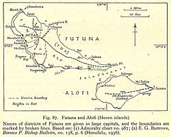
Sigave encompasses the western third of Futuna Island (30 km2 of Futuna Island's total area of 83 km2). Sigave has six villages, which together had a population of 1,275 as of the 2018 census. The capital and largest village is Leava (pop. 322).
Administrative division[]
The chiefdom of Sigave is coextensive with the district of the same name. Its six villages (or municipalities) are as follows:[2]
| Village | Population | District | Zone |
|---|---|---|---|
| Leava | 322 | Sigave | West to Southwest Coast |
| Toloke | 172 | Sigave | West to Southwest Coast |
| Nuku | 204 | Sigave | West to Southwest Coast |
| Fiua | 257 | Sigave | West to Southwest Coast |
| Vaisei | 160 | Sigave | West to Southwest Coast |
| Tavai | 160 | Sigave | North Coast |
History[]
Education[]
This section needs expansion. You can help by . (September 2016) |
The junior high school in the area is Collège Fiua de Sigave.[3]
See also[]
References[]
- ^ Coextensive with the chiefdom
- ^ "Population municipale des villages des îles Wallis et Futuna (recensement 2018)". INSEE. Retrieved 21 February 2020.
- ^ "Cartographie des établissements du second degré." Wallis and Futuna. June 24, 2016. Retrieved on September 14, 2016.
External links[]
![]() Media related to Sigave at Wikimedia Commons
Media related to Sigave at Wikimedia Commons
Wallis and Futuna articles | |||
|---|---|---|---|
| |||
| Islands |  | ||
| Chiefdoms | |||
| Geography |
| ||
| Politics |
| ||
| Economy |
| ||
| Culture |
| ||
| |||
This Wallis and Futuna location article is a stub. You can help Wikipedia by . |
- Chiefdoms and districts of Wallis and Futuna
- Non-metropolitan France geography stubs
- Oceania geography stubs
- Wallis and Futuna stubs