Silver City Historic District (Idaho)
Silver City Historic District | |
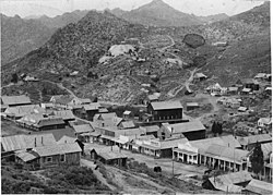 Silver City in 1892 | |
 | |
| Location | Owyhee County, Idaho United States |
|---|---|
| Nearest city | Jordan Valley, Oregon |
| Coordinates | 43°01′01″N 116°43′59″W / 43.01694°N 116.73306°WCoordinates: 43°01′01″N 116°43′59″W / 43.01694°N 116.73306°W |
| Area | 10,240 acres (41.4 km2) |
| NRHP reference No. | 72000446[1] |
| Added to NRHP | May 19, 1972 |

The Silver City Historic District is a historically significant mining area in northwestern Owyhee County, Idaho, United States.[1] It includes the abandoned town of Silver City and numerous nearby towns, mines, and mining remains, covering approximately 16 square miles (41 km2). Along with Silver City, it encompasses the communities of Ruby City, , Dewey, and ,[2] along with major silver mines on [3] and .[4]
See also[]
References[]
- ^ a b "National Register Information System". National Register of Historic Places. National Park Service. March 13, 2009.
- ^ U.S. Geological Survey Geographic Names Information System: Fairview
- ^ U.S. Geological Survey Geographic Names Information System: War Eagle Mountain
- ^ U.S. Geological Survey Geographic Names Information System: Florida Mountain
External links[]
![]() Media related to Silver City Historic District (Idaho) at Wikimedia Commons
Media related to Silver City Historic District (Idaho) at Wikimedia Commons
| Topics | |
|---|---|
| Lists by state |
|
| Lists by insular areas | |
| Lists by associated state | |
| Other areas | |
| Related | |
| |
This article about a property in Idaho on the National Register of Historic Places is a stub. You can help Wikipedia by . |
Categories:
- Silver City Historic District (Idaho)
- Geography of Grant County, New Mexico
- Historic districts on the National Register of Historic Places in New Mexico
- National Register of Historic Places in Grant County, New Mexico
- Idaho Registered Historic Place stubs