Silver Peak (El Dorado County, California)
| Silver Peak | |
|---|---|
 | |
| Highest point | |
| Elevation | 8,934 ft (2,723 m) NAVD 88[1] |
| Prominence | 250 ft (76 m)[1] |
| Listing | Tahoe OGUL Mountaineer Peak[2] |
| Coordinates | 38°51′50″N 120°10′29″W / 38.8638688°N 120.17472814°WCoordinates: 38°51′50″N 120°10′29″W / 38.8638688°N 120.17472814°W[3] |
| Geography | |
| Location | El Dorado County, California, U.S. |
| Parent range | Sierra Nevada |
| Climbing | |
| Easiest route | Scramble, class 2[2] |

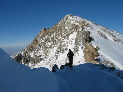
Silver Peak is a mountain in the Sierra Nevada mountain range at the north end of the Crystal Mountains, to the east of Lake Tahoe. It is located in the Desolation Wilderness in El Dorado County, California.
External links[]
 Media related to Silver Peak (El Dorado County, California) at Wikimedia Commons
References[]
- ^ a b "Silver Peak, California". Peakbagger.com. Retrieved 2014-01-19.
- ^ a b "Tahoe OGUL Peaks List". Retrieved 2021-11-07.
- ^ "Silver Peak". Geographic Names Information System. United States Geological Survey. Retrieved 2012-12-12.
This El Dorado County, California–related article is a stub. You can help Wikipedia by . |
Categories:
- Mountains of the Desolation Wilderness
- Mountains of El Dorado County, California
- Mountains of Northern California
- El Dorado County, California geography stubs