Sinclairs Bay
| Sinclair's Bay | |
|---|---|
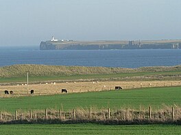 Noss Head, lighthouse from across Sinclair's Bay | |
 Sinclair's Bay | |
| Location | Caithness, Scotland |
| Coordinates | 58°30′20.5848″N 3°05′38.7960″W / 58.505718000°N 3.094110000°WCoordinates: 58°30′20.5848″N 3°05′38.7960″W / 58.505718000°N 3.094110000°W |
| River sources | River of Wester |
| Ocean/sea sources | North Sea |
| Basin countries | Scotland |
| Max. length | 9.45 km (5.87 mi) |
| Max. width | 3.51 km (2.18 mi) |
| Average depth | 16.2 metres (53 ft) |
Sinclairs Bay is a large remote, breast shaped, or left leaf of a tear drop shaped, coastal embayment, on the east coast of Scotland, in east Caithness, in the district of the east Highlands.[1] Its coastline falls entirely within the Scottish council area of Highland.[2]
Geography[]
Starting in the north, at , the bay is bounded by , and overlooked by , the bay proper sweeps south in a long elliptical curve, before sweeping east to pass the remains Castle Sinclair and terminating at Noss Head Lighthouse.[3]
Sinclairs Bay has two primary geological features. Starting at the coastal village of Keiss, running northeast, a stony beach and coastal crags, become cliffs that are increasingly sheer the further north. South of Keiss, the cliffs even out in a large white sandy beach, called Keiss Beach, forming large Dunes further south. At Ackergill Tower, the beach again becomes stony and eventually forms into a series of cliffs and crags, further east.
References[]
- ^ Robert Sinclair (12 June 2013). The Sinclairs of Scotland. AuthorHouse. p. 6. ISBN 978-1-4817-9623-1. Retrieved 29 June 2017.
- ^ James Tait Calder (1861). Sketch of the Civil and Traditional History of Caithness, from the Tenth Century. Thomas Murray and Son. pp. 18–.
- ^ Ordnance Survey (2009) "Get-a-map". Retrieved 14 August 2011.
- Caithness
- Bays of Highland (council area)