Singhpur, Raebareli
Singhpur | |
|---|---|
Village | |
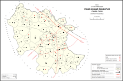 Map of Singhpur CD block | |
 Singhpur Location in Uttar Pradesh, India | |
| Coordinates: 26°28′55″N 81°26′31″E / 26.481904°N 81.441914°ECoordinates: 26°28′55″N 81°26′31″E / 26.481904°N 81.441914°E[1] | |
| Country India | |
| State | Uttar Pradesh |
| District | Raebareli |
| Area | |
| • Total | 6.116 km2 (2.361 sq mi) |
| Population (2011)[2] | |
| • Total | 2,826 |
| • Density | 460/km2 (1,200/sq mi) |
| Languages | |
| • Official | Hindi |
| Time zone | UTC+5:30 (IST) |
| PIN | 229308[2] |
| Vehicle registration | UP-35 |

Singhpur is a village and corresponding community development block in Tiloi tehsil of Rae Bareli district, Uttar Pradesh, India.[2] As of 2011, its population is 2,826, in 549 households.[2] It is located 16 km from Tiloi, the tehsil headquarters,[3] and 20 km from the town of Maharajganj.[4] The main staple foods are wheat and rice.[4]
The 1961 census recorded Singhpur as comprising 11 hamlets, with a total population of 1,179 people (617 male and 562 female), in 303 households and 296 physical houses.[3] The area of the village was given as 998 acres.[3]
The 1981 census recorded Singhpur as having a population of 1,418 people, in 317 households, and having an area of 396.60 hectares.[4]
Villages[]
Singhpur CD block has the following 74 villages:[2]
| Village name | Total land area (hectares) | Population (in 2011) |
|---|---|---|
| 213.6 | 2,590 | |
| 25.4 | 298 | |
| 171.4 | 961 | |
| 512.3 | 2,282 | |
| 576.8 | 3,711 | |
| 753.5 | 4,557 | |
| 160.5 | 1,050 | |
| 146.2 | 805 | |
| 197.1 | 1,612 | |
| Lauli | 481.5 | 2,864 |
| 107.8 | 551 | |
| 248.4 | 2,164 | |
| 281 | 1,967 | |
| 177.1 | 1,582 | |
| 52.8 | 457 | |
| 17 | 3,059 | |
| 47 | 550 | |
| Naukhera | 283.8 | 1,668 |
| 39.2 | 399 | |
| Anguri | 184.3 | 1,373 |
| Ashrafpur | 126 | 1,037 |
| Chilauli | 213.3 | 2,616 |
| Kotwa | 570.3 | 4,832 |
| 716.8 | 7,719 | |
| 228.1 | 1,574 | |
| 127.5 | 1,575 | |
| 103.3 | 1,477 | |
| Khara | 1,158.2 | 7,320 |
| 276.3 | 2,923 | |
| 217.7 | 1,512 | |
| 300.4 | 1,527 | |
| 549 | 3,651 | |
| 350 | 2,320 | |
| 387 | 2,128 | |
| 553.9 | 2,289 | |
| Singhpur (block headquarters) | 611.6 | 2,826 |
| Panhauna | 890.7 | 7,075 |
| 36.8 | 522 | |
| 78.6 | 1,328 | |
| 39.7 | 469 | |
| 186.4 | 1,256 | |
| 155.4 | 1,129 | |
| 222 | 1,850 | |
| 250.9 | 914 | |
| 92 | 1,491 | |
| Inhauna | 862 | 13,049 |
| Sarai Madho | 259 | 1,212 |
| 277 | 2,230 | |
| 565.2 | 6,373 | |
| 31.6 | 248 | |
| 74.9 | 670 | |
| 307 | 2,808 | |
| Jijauli | 303.6 | 1,664 |
| 834.6 | 1,434 | |
| 102.8 | 1,857 | |
| 1,028 | 2,615 | |
| Fatehpur | 368.8 | 5,348 |
| Rajapur | 346 | 3,954 |
| 246.1 | 2,900 | |
| 195.4 | 993 | |
| 473 | 2,726 | |
| 374 | 3,896 | |
| Phoola | 1,359.7 | 7,726 |
| 91.3 | 543 | |
| Hasanpur | 121.5 | 1,162 |
| Konchi | 264.3 | 1,914 |
| Rasta Mau | 697.1 | 7,859 |
| Chilauli | 529.3 | 3,429 |
| Karan Gaon | 470.7 | 3,500 |
| 433.3 | 5,645 | |
| Mirzagarh | 258.5 | 2,596 |
| 491.3 | 4,738 | |
| 244.9 | 2,682 | |
| 293 | 2,625 |
References[]
- ^ Do a radial search using these coordinates here https://geonames.nga.mil/namesgaz/.
{{cite web}}: Missing or empty|title=(help) - ^ a b c d e f "Census of India 2011: Uttar Pradesh District Census Handbook - Rae Bareli, Part A (Village and Town Directory)" (PDF). Census 2011 India. pp. 125–41. Retrieved 28 July 2021.
- ^ a b c Census 1961: District Census Handbook, Uttar Pradesh (39 - Raebareli District) (PDF). Lucknow. 1965. pp. 149, xx-xxi of section "Maharajganj Tahsil". Retrieved 28 July 2021.
- ^ a b c Census 1981 Uttar Pradesh: District Census Handbook Part XIII-A: Village & Town Directory, District Rae Bareli (PDF). 1982. pp. 48–9. Retrieved 28 July 2021.
This Raebareli district location article is a stub. You can help Wikipedia by . |
- Villages in Raebareli district
- Lucknow division geography stubs