Sinnar
Sinnar | |
|---|---|
 | |
 Sinnar Location in Maharashtra, India | |
| Coordinates: 19°51′N 74°00′E / 19.85°N 74.0°ECoordinates: 19°51′N 74°00′E / 19.85°N 74.0°E | |
| Country | |
| State | Maharashtra |
| District | Nashik |
| Area | |
| • Total | 195 km2 (75 sq mi) |
| Elevation | 651 m (2,136 ft) |
| Population (2001) | |
| • Total | 65,299 |
| • Density | 330/km2 (870/sq mi) |
| Languages | |
| • Official | Marathi |
| Time zone | UTC+5:30 (IST) |
| Telephone code | 02551 |
| Vehicle registration | MH 15 |

Sinnar is a city and a municipal council in Sinnar taluka of Nashik district in the Indian state of Maharashtra.
History[]
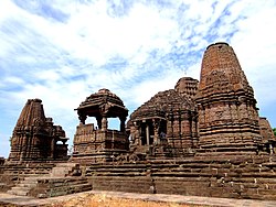
According to local tradition, the town of Sinnar was established by the Gavali (Yadava) chief Rav Singuni.[1] His son Rav Govinda built the great temple of Gondeshwara or Govindeshwara, at a cost of 2 lakh rupees.[2] Traditionally, Seuna Yadavas are called "Gavli Kings". Bhillama V (1185–93) moved their capital from Sinnar, near Nashik, to Devagiri. Like Hoysala Yadavas, Seunas Yadavas were also originally pastoralists or cattle-herders. The Yadavas often proudly claimed their pastoral ancestry.[3][4]
At its peak, the Seuna or Yadava dynasty (850 - 1334) ruled a kingdom stretching from the Tungabhadra to the Narmada Rivers, including present-day Maharashtra, north Karnataka and parts of Madhya Pradesh. The capital was at Devagiri, now known as Daulatabad in Maharashtra. The reign of the Yadava dynasty declined after the conquest of the Daulatabad Fort by Alauddin Khalji in 1294. Further conquest by Malik Kafur, Alauddin's general, in 1312 resulted in the killing of the members of the Yadava clan ending this illustrious dynasty. It is also the birthplace of Baji Rao I,the mighty general of Maratha Empire.
Geography[]
Sinnar is located at 19°51′N 74°00′E / 19.85°N 74.0°E.[5] It has an average elevation of 651.4 metres (2135 feet). Sinnar is one of the major industrial zones of Malegaon (MIDC) built around the city of Nashik which have multiple international production companies. It lies 30 km southeast of Nashik city on the Pune - Nashik Highway.
Demographics[]
As of 2001 India census,[6] Sinnar had a population of 65,299. Males constitute 52% of the population and females 48%. Sinnar has an average literacy rate of 71%, higher than the national average of 59.5%: male literacy is 77%, and female literacy is 64%. In Sinnar, 15% of the population is under 6 years of age.
Culture[]
The Gondeshwar Temple, an 11th-12th century temple dedicated to Shiva, is located in Sinnar.
The Gargoti Museum houses a collection of mineral specimens native to the region.
References[]
- ^ Verma, Onkar Prasad (1973). A Survey of Hemadpanti Temples in Maharashtra. Nagpur University, 1973. p. 9.
- ^ Kanhere, Gopal Krishna (1989). The Temples of Maharashtra. Maharashtra Information Centre (Directorate-General of Information and Public Relations, Bombay), Government of Maharashtra, 1989. p. 45.
- ^ Dhere, Ramchandra (2011). Rise of a Folk God: Vitthal of Pandharpur South Asia Research. Oxford University Press, 2011. pp. 246–247. ISBN 9780199777648.
- ^ Dhavalikar, Madhukar (2014). Socio-economic Archaeology of India. Archaeological Survey of India, 2014. p. 274.
- ^ Falling Rain Genomics, Inc - Sinnar
- ^ "Census of India 2001: Data from the 2001 Census, including cities, villages and towns (Provisional)". Census Commission of India. Archived from the original on 16 June 2004. Retrieved 1 November 2008.
| Wikimedia Commons has media related to Sinnar. |
| show Nashik district topics |
|---|

| show Authority control |
|---|
- Cities and towns in Nashik district
- Nashik Division geography stubs