Skelsmergh and Scalthwaiterigg
Skelsmergh and Scalthwaiterigg is a civil parish in South Lakeland district, Cumbria, England. It was formed on 1 April 2015 by merging the parishes of Skelsmergh and Scalthwaiterigg,[1] which had shared a parish council since 2007.[2]
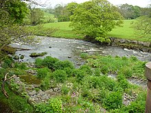
The parish is divided into two wards, separated by the River Mint and named for the two previous parishes.[3] Skelsmergh parish ward (north of the river) is represented by five councillors, and Scalthwaiterigg parish ward (south of the river) by two councillors, a pattern established in 2007.[2]
The population of the former parish of Skelsmergh was 303 in the 2011 United Kingdom census;[4] the 2011 population of the former parish of Scalthwaiterigg is not available, but its 2001 population was 104.[5] (the 2001 population of Skelsmergh was 271).[6]
The areas of the two former parishes were 7.8435 km2 (3.0284 sq mi) (Skelsmergh)[4] 4.22 km2 (1.63 sq mi) (Scalthwaiterigg),[5] giving an area for the current parish of 12.02635 km2 (4.64340 sq mi). The southern part of the parish includes the 317 metres (1,040 ft) hill , which is classified as a HuMP, a TuMP and a Clem.[7] The A6 from Kendal to Shap, the A685 road from Kendal to Tebay, and the Dales Way footpath from Ilkley to Bowness all pass through the parish.[3]
There are eight listed buildings in the parish, all at grade II.
See also[]
References[]
- ^ "Chairman's Annual Report 2015/16" (PDF). Skelsmergh and Scalthwaiterigg Parish Council. 2016. Retrieved 18 October 2021.
- ^ a b "South Lakeland District (Parishes of Skelsmergh and Scalthwaiterigg) Grouping Order 2007" (PDF). Local Government Boundary Commission for England. Retrieved 18 October 2021.
- ^ a b South Lakeland District Council. "Skelsmergh and Scalthwaiterigg Parish" (PDF). Skelsmergh and Scalthwaiterigg Parish Council. Retrieved 18 October 2021. Ordnance Survey 1:25,000 map showing the parish and ward boundaries
- ^ a b UK Census (2011). "Local Area Report – Skelsmergh Parish (E04002648)". Nomis. Office for National Statistics. Retrieved 18 October 2021.
- ^ a b UK Census (2001). "Local Area Report – Scalthwaiterigg Parish (16UG062)". Nomis. Office for National Statistics. Retrieved 18 October 2021.
- ^ UK Census (2001). "Local Area Report – Skelsmergh Parish (16UG065)". Nomis. Office for National Statistics. Retrieved 18 October 2021.
- ^ "Benson Knott". www.hill-bagging.co.uk. Retrieved 18 October 2021.
External links[]

- Civil parishes in Cumbria
- South Lakeland District
- 2015 establishments in England