Skilly Peak

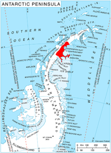
Location of Oscar II Coast on Antarctic Peninsula.
Skilly Peak (64°59′S 61°16′W / 64.983°S 61.267°WCoordinates: 64°59′S 61°16′W / 64.983°S 61.267°W) is a conspicuous rock peak 4.3 miles (6.9 km) northeast of Shiver Point and 3.5 miles (5.6 km) northeast of Eduard Nunatak on the east coast of Graham Land, Antarctica. It surmounts Rogosh Glacier to the north and Artanes Bay to the southeast.
The peak was surveyed by Falkland Islands Dependencies Survey (FIDS) in 1947 and 1955. "Skilly" means a thin soup; the name arose because the 1955 FIDS party was short of rations, and pemmican and porridge were very thin.
![]() This article incorporates public domain material from the United States Geological Survey document: "Skilly Peak". (content from the Geographic Names Information System)
This article incorporates public domain material from the United States Geological Survey document: "Skilly Peak". (content from the Geographic Names Information System) ![]()
Categories:
- Mountains of Graham Land
- Oscar II Coast
- Oscar II Coast geography stubs
 WikiMiniAtlas