Skrapež (river)
This article needs additional citations for verification. (January 2017) |
| Skrapež | |
|---|---|
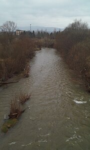 River Skrapež in Požega, March 2017 | |
| Location | |
| Country | Serbia |
| Municipalities | Kosjerić, Valjevo, Požega |
| Physical characteristics | |
| Source | |
| • location | Povlen, Kosjerić, Zlatibor |
| Mouth | |
• location | Đetinja, near Požega, Zlatibor |
• coordinates | 43°50′29″N 20°04′01″E / 43.84146°N 20.06706°ECoordinates: 43°50′29″N 20°04′01″E / 43.84146°N 20.06706°E |
• elevation | 300 m (980 ft) |
| Length | 47.7 km (29.6 mi) |
| Basin size | 630 km2 (240 sq mi) |
| Basin features | |
| Progression | Đetinja→ West Morava→ Great Morava→ Danube→ Black Sea |
| Tributaries | |
| • left | , , |
| • right | |

Skrapež (Serbian Cyrillic: Скрапеж; pronounced [skrâːpeʒ]), is a river in central Serbia. It is 47.7 kilometres (29.6 mi) long and it flows into Đetinja river, which some 1.5 kilometres (0.93 mi) later creates West Morava, along with the Golijska Moravica. Skrapež belongs to the Black Sea drainage basin. The river originates on the southeastern slope of Povlen mountain, at the confluence of two smaller rivers: Sečnica and Godljevača.[1]
References[]
- ^ "Izvor reke Skrapež" (in Serbian). Retrieved 17 January 2017.
Bibliography[]
- Mala enciklopedija Prosveta (3 ed.). Beograd: Prosveta. 1985. ISBN 978-86-07-00001-2. Missing or empty
|title=(help) - Marković, Jovan Đ. (1990). Enciklopedijski geografski leksikon Jugoslavije. Sarajevo: Svjetlost. ISBN 978-86-01-02651-3.
| Authority control: National libraries |
|---|
Categories:
- Tributaries of the West Morava
- Rivers of Serbia
- Zlatibor District
- Kolubara District