Skuta Glacier
| Skuta Glacier | |
|---|---|
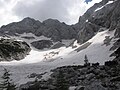
 Skuta Glacier and its snow fields in summer of 2014. | |
 Skuta Glacier Location in Slovenia  Skuta Glacier Skuta Glacier (Alps) | |
| Type | Mountain glacier |
| Location | mountain Skuta in Kamnik-Savinja Alps in Slovenia |
| Coordinates | 46°21′54.97″N 14°33′36.36″E / 46.3652694°N 14.5601000°ECoordinates: 46°21′54.97″N 14°33′36.36″E / 46.3652694°N 14.5601000°E |
| Area | 1.7 ha (4.2 acres) |
| Status | Retreating |
 | |
Skuta Glacier (Slovenian: Ledenik pod Skuto), located beneath mountain Skuta in Kamnik-Savinja Alps in Slovenia is the most south-eastern glacier in the Alps.
Geography[]
Skuta Glacier had an area of 2.8 hectares in 1950 and 1.6 in 2013.[1] Reaching 2020 metres above sea level at its lowest point, it is also one of the lowest elevation glaciers in the Alps.[2]
Triglav glacieret is the second remaining glacier in Slovenia at the elevation of 2500 m.
Skuta Glacier in figures[]
- Area: 1.7 hectares (4.2 acres) (as of 2007)[1]
- Elevation: 2,020–2,120 m (6,630–6,960 ft)[1]
- Average ice thickness: 7 m (23 ft) (as of September 2006)[1]
- Maximum ice thickness: 12 m (39 ft) (as of September 2006)[1]
- Volume: 80,000 m3 (2,800,000 cu ft) (as of September 2006)[1]
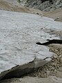
Snow fields beneath the glacier.

Snow fields around the Skuta Glacier.

Snow fields beneath the Skuta Glacier.

The glacier gives birth to the small stream.
Glacier snow.

Chamois passing the glacier.


References[]
- ^ a b c d e f http://giam.zrc-sazu.si/?q=sl/node/421 Archived 2014-01-11 at the Wayback Machine
- ^ "Triglavski ledenik izginja počasneje od napovedi". October 2013.
This article about a glacier is a stub. You can help Wikipedia by . |
Categories:
- Glaciers of Slovenia
- Glaciers of the Alps
- Landforms of Upper Carniola
- Glacier stubs