Snønipa
| Snønipa | |
|---|---|
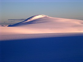 Snønipa, seen from the glacier Myklebustbreen | |
| Highest point | |
| Elevation | 1,827 m (5,994 ft) |
| Prominence | 733.7 to 733.9 m (2,407 to 2,408 ft) |
| Isolation | 10.96 to 10.98 km (6.81 to 6.82 mi) |
| Coordinates | 61°40′41″N 6°41′26″E / 61.6781°N 6.6905°ECoordinates: 61°40′41″N 6°41′26″E / 61.6781°N 6.6905°E[1] |
| Geography | |
 Snønipa Location of the mountain | |
| Location | Vestland, Norway |
| Parent range | Breheimen |


Snønipa is a mountain in Vestland county, Norway. The 1,827-metre (5,994 ft) tall mountain lies on the border of the municipalities of Sunnfjord and Gloppen. It forms a nunatak of the Myklebustbreen glacier.[2][3]
References[]
- ^ "Snønipa, Jølster (Sogn og Fjordane)" (in Norwegian). yr.no. Retrieved 2019-09-15.
- ^ Lauritzen, Per Roger, ed. (2009). "Snønipa". Norsk Fjelleksikon (in Norwegian). Arendal: Friluftsforlaget. ISBN 978-82-91-49547-7.
- ^ Godal, Anne Marit (ed.). "Snønipa". Store norske leksikon (in Norwegian). Oslo: Norsk nettleksikon. Retrieved 24 October 2013.
This Vestland location article is a stub. You can help Wikipedia by . |
Categories:
- Mountains of Vestland
- Sunnfjord
- Gloppen
- Vestland geography stubs