Sokcho Airport
Sokcho Air Base 속초공항 | |||||||||||
|---|---|---|---|---|---|---|---|---|---|---|---|
| Summary | |||||||||||
| Airport type | Military | ||||||||||
| Owner | ROKAF | ||||||||||
| Operator | ROKAF | ||||||||||
| Location | Sokcho, South Korea | ||||||||||
| Elevation AMSL | 92 ft / 28 m | ||||||||||
| Coordinates | 38°08′33″N 128°35′54″E / 38.14250°N 128.59833°E | ||||||||||
| Runways | |||||||||||
| |||||||||||

Sokcho Air Base (IATA: SHO, ICAO: RKND) is an air base in Sokcho, a city in the Gangwon province of South Korea.[1][2]
The airport had a single 1,560 meter runway (05/23). It used to serve people who went to Seoraksan for hiking. The airport was closed prior to the opening of Yangyang International Airport.[citation needed]
During the Korean War the USAF designated the base as K-50.
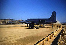
Unloading mail at K-50, Sokcho-Ri, December 1951
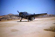
Grumman Avenger converted to repair plane K-50, Sokcho, 24 December 1951

References[]
- ^ Jump up to: a b Airport information for RKND at World Aero Data. Data current as of October 2006.Source: DAFIF.
- ^ Jump up to: a b Airport information for SHO at Great Circle Mapper. Source: DAFIF (effective October 2006).
External links[]
| hide | |
|---|---|
| Major International | |
| Minor International | |
| Domestic | |
| Military | |
| Related lists | |
| |
This article about the Korean War is a stub. You can help Wikipedia by . |
Categories:
- Airports in South Korea
- Sokcho
- Buildings and structures in Gangwon Province, South Korea
- Korean War air bases
- Korean War stubs