Somba Opu, Gowa
Somba Opu | |
|---|---|
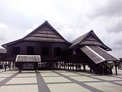 Balla' lompoa museum | |
 Location of Somba Opu District | |
| Coordinates: 5°12′5″S 119°27′15″E / 5.20139°S 119.45417°E | |
| Country | |
| Province | South Sulawesi |
| Regency | Gowa Regency |
| Government | |
| • Camat | Drs. Abdullah Siradjuddin, MSi |
| Area | |
| • Total | 28.09 km2 (10.85 sq mi) |
| Population (2018) | |
| • Total | 169,118 |
| • Density | 6,000/km2 (16,000/sq mi) |
| Time zone | UTC+8 (Indonesia Central Time) |
| Postal Code | 9211x |
| Area code | (+62) 411 |

Somba Opu is a district located in the Gowa Regency. South Sulawesi, Indonesia, and is part of the greater Makassar area. Somba Opu is one of 18 districts in Gowa Regency. The capital of Gowa, "Sungguminasa" is located in this district and this is the largest regency capital or 2nd largest city in South Sulawesi. A suburb to Makassar, the subdistrict is a relatively urbanized area, and can also be called as the city's bedroom community.
Although Somba Opu isn't considered as an official town or city, it has a high population density of 6,021 people per km, and a population of 169,118, all packed into an area of about 28.09 square kilometres.[1]
Geography[]
The total area of 28.09 km2 or 2,809 Ha (1.49% of the total area of Gowa Regency) with the altitude of the area / altitude is 25 meters above sea level. Most of the area is located in the lowlands with Geographic coordinates at 5°12'5"S 119°27'15"E. The natural border with the sub-district of Pallangga is the Jeneberang River which is a river with a length of 90 km and an area of the River Basin 881km2
Main Sights[]
- Balla Lompoa Museum is a reconstruction of the royal palace of Gowa, which was established during the reign of the 31st King of Gowa, I Mangngi-mangngi Daeng Matutu, in 1936. In Makassar, Balla Lompoa means a large house or the House of greatness. The architecture of this museum building is in the form of a typical Bugis house, a stilt house, with a ladder more than two meters high to enter the patio space. The entire building is made of ironwood or iron wood. This building is in a one hectare complex that is bordered by a high wall fence. This museum serves as a place to store collections of Gowa Kingdom objects. The historical objects are displayed based on the general function of each room in the museum building. At the front of the main building, a map of the Kingdom of Gowa is displayed on the right side of the wall. In the main room the family tree of the Gowa Kingdom starts from the King Gowa I, Tomanurunga in the 13th century, until the last Gowa King Sultan Moch Abdulkadir Aididdin A. Idjo Karaeng Lalongan (1947-1957). Note: Other sources call it Andi Ijo Daeng Mattawang Karaeng Lalolang Sultan Muhammad Abdul Kadir Aididdin.
- Al-Hilal Mosque or better known as Katangka Mosque is one of the oldest mosques in the province of South Sulawesi, Indonesia. Named Katangka Mosque because it is located in the village of Katangka, Somba Opu District, Gowa Regency. In addition, the mosque is called Katangka, because the basic raw materials of the mosque are believed to be taken from the Katangka tree.
Shopping Center and Restaurant[]
Supermarket[]
- Satu Sama Supermarket
Traditional Market[]
- Sungguminasa People's Market
- Minasa Maupa modern Market
Restaurant[]
- KFC Citraland
- Pizza Hut Citraland
- Burger King Hertasning
- McDonald's Hertasning
Education[]
- Alauddin Islamic State University
- Patria Artha University
Villages[]
Somba Opu is divided into 14 villages
| Postalcode | Villages | Area (km2) | Population | Neighborhood |
|---|---|---|---|---|
| 92117 | Batangkaluku | 1.30 | 16,861 | 1. Karettapa 2. Batangkaluku |
| 92111 | Bonto-bontoa | 1.61 | 15,603 | 1. Bonto-bontoa 2. Bontokamase |
| 92119 | Bontoramba | 2.12 | 4,458 | 1. Bontobaddo 2. Galoggoro |
| 92116 | Kalegowa | 1.21 | 3,085 | 1. Tamalate 2. Hasanuddin |
| 92114 | Katangka | 1.36 | 12,146 | 1. Lakiyung 2. Katangka |
| 92119 | Mawang | 2.99 | 5,241 | 1. Buttadidi 2. Biringbalang |
| 92113 | Paccinongang | 3.71 | 25,665 | 1. Pao-Pao 2. Paccinongang |
| 92115 | Pandang-Pandang | 2.16 | 9,322 | 1. Pandang-Pandang 2. Mangasa |
| 92118 | Romangpolong | 2.71 | 8,411 | 1. Romangpolong 2. Garaganti |
| 92113 | Samata | 1.44 | 9,020 | 1. Samata 2. Borongraukang |
| 92111 | Sungguminasa | 1.46 | 9,345 | 1. Sungguminasa 2. Lambaselo |
| 92112 | Tamarunang | 2.16 | 16,793 | 1. Paggentungan 2. Beroanging |
| 92114 | Tombolo | 2.06 | 18,651 | 1. Pa'bangngiang 2. Tombolo |
| 92112 | Tompobalang | 1.80 | 13,390 | 1. Cambaya 2. Jeneberang |
References[]
- ^ Badan Pusat Satistik Kabupaten Gowa, 2019, Jumlah Penduduk Kabupaten Gowa Menurut Kecamatan, 2009-2018
- South Sulawesi