Songhwa County
This article needs additional citations for verification. (October 2021) |
Songhwa County
송화군 | |
|---|---|
| Korean transcription(s) | |
| • Hanja | 松禾郡 |
| • McCune-Reischauer | Songhwa-kun |
| • Revised Romanization | Songhwa-gun |
 | |
| Country | North Korea |
| Province | South Hwanghae Province |
| Area | |
| • Total | 193.2 km2 (74.6 sq mi) |
| Population (2008[1]) | |
| • Total | 44,274 |
| • Density | 230/km2 (590/sq mi) |
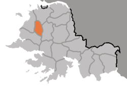
Songhwa County is a county in South Hwanghae province, North Korea.
Administrative divisions[]
Songhwa county is divided into 1 ŭp (town) and 10 ri (villages):
|
History[]
The area was called Kuŭlhyŏn (仇乙縣) or Kulch'ŏn (屈遷) in the Koguryŏ era. It became part of Songhwa County in 1895, and in March 1909, Songhwa County was merged with P'ungch'ŏn County. Songhwa county was recreated in the 1952 reorganisation of North Korea's administrative divisions. The northwestern section of the county was split off in 1967 to create Kwail county.
Transportation[]
Songhwa county is served by the Changyŏn and Ŭllyul lines of the Korean State Railway.
References[]
| Capital |  | |
|---|---|---|
| Cities | ||
| Counties | ||
This North Korea location article is a stub. You can help Wikipedia by . |
Categories:
- Counties of South Hwanghae
- North Korea geography stubs