Sourdough Peak
| Sourdough Peak | |
|---|---|
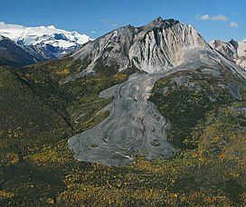 Sourdough Peak with rock glacier | |
| Highest point | |
| Elevation | 6,201 ft (1,890 m)[1] |
| Prominence | 1,901 ft (579 m)[1] |
| Isolation | 3.64 mi (5.86 km)[2] |
| Coordinates | 61°24′45″N 142°44′10″W / 61.412504°N 142.7361°WCoordinates: 61°24′45″N 142°44′10″W / 61.412504°N 142.7361°W[3] |
| Geography | |
 Sourdough Peak Location of Sourdough Peak in Alaska | |
| Location | Wrangell-St. Elias National Park Valdez-Cordova Borough Alaska, United States |
| Parent range | Wrangell Mountains |
| Topo map | USGS McCarthy B-5 |
Sourdough Peak is a 6,201-foot (1,890 meter) mountain summit located at the southern edge of the Wrangell Mountains, in the U.S. state of Alaska. The peak is situated in Wrangell-St. Elias National Park and Preserve, 7 mi (11 km) east-southeast of McCarthy, on the north bank of the Nizina River. The peak is notable for a rock glacier on its south slope. The peak's name was used by early prospectors as reported in 1908 by the USGS.[3] A "sourdough" is defined as an experienced prospector or an old-timer in the western US or Canada, because they always carried sourdough starter with them. Sourdough Peak's nearest higher neighbor is Porphyry Mountain, 5.1 miles to the northwest.
Climate[]

Based on the Köppen climate classification, Sourdough Peak is located in a subarctic climate zone with long, cold, snowy winters, and cool summers.[4] Winds coming off the Gulf of Alaska are forced upwards by the Wrangell Mountains (orographic lift), causing heavy precipitation in the form of rainfall and snowfall. Temperatures can drop below −20 °C with wind chill factors below −30 °C. The months May through June offer the most favorable weather for viewing and climbing.
See also[]
References[]
- ^ a b "Sourdough Peak, Alaska". Peakbagger.com. Retrieved 2020-01-31.
- ^ Sourdough Peak, listsofjohn.com
- ^ a b "Sourdough Peak". Geographic Names Information System. United States Geological Survey. Retrieved 2020-01-31.
- ^ Peel, M. C.; Finlayson, B. L.; McMahon, T. A. (2007). "Updated world map of the Köppen−Geiger climate classification". Hydrol. Earth Syst. Sci. 11. ISSN 1027-5606.
External links[]
- Weather forecast: Sourdough Peak
- Mountains of Alaska
- Landforms of Copper River Census Area, Alaska
- Wrangell–St. Elias National Park and Preserve
- North American 1000 m summits