Souris Island
Native name: Ile aux Souris Nickname: Rat Island | |
|---|---|
 Souris Island | |
| Geography | |
| Location | Seychelles, Indian Ocean |
| Coordinates | 4°37′S 55°30′E / 4.617°S 55.500°ECoordinates: 4°37′S 55°30′E / 4.617°S 55.500°E |
| Archipelago | Inner Islands, Seychelles |
| Adjacent bodies of water | Indian Ocean |
| Total islands | 1 |
| Major islands |
|
| Area | 0.005 km2 (0.0019 sq mi) |
| Length | 0.1 km (0.06 mi) |
| Width | 0.1 km (0.06 mi) |
| Coastline | 0.25 km (0.155 mi) |
| Highest elevation | 14 m (46 ft) |
| Highest point | Souris |
| Administration | |
| Group | Granitic Seychelles |
| Sub-Group | Mahe Islands |
| Districts | Anse Royale |
| Demographics | |
| Population | 0 (2014) |
| Pop. density | 0/km2 (0/sq mi) |
| Ethnic groups | Creole, French, East Africans, Indians. |
| Additional information | |
| Time zone | |
| ISO code | SC-05 |
| Official website | www |

Ile aux Souris is an island in Seychelles, lying in the eastern shores of Mahe.
With a 14-metre elevation ‘it stands just inside the long line of coral reef fringing the coasts of Anse Royale and . It is rocky, about 500 metres south west of Pointe au Sel. In the vicinity you can find the Seychelles university.
The island belongs to Anse Royale District.[1]
Image gallery[]

Map 1

District Map
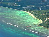
Souris Island in front of the University of Mahe


References[]
External links[]
This Seychelles location article is a stub. You can help Wikipedia by . |
Categories:
- Islands of Mahé Islands
- Uninhabited islands of Seychelles
- Seychelles geography stubs