South Carolina Highway 119

From Wikipedia, the free encyclopedia
South Carolina Highway 119 marker
South Carolina Highway 119
Route information
Maintained by SCDOT
Length5.990 mi[1][2] (9.640 km)
Major junctions
South end SR 119 at the Georgia state line south-southwest of Garnett
North end US 321 in Garnett
Location
CountiesJasper, Hampton
Highway system
SC 118 SC 120

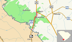
South Carolina Highway 119 (SC 119) is a 5.990-mile (9.640 km) state highway in the U.S. state of South Carolina. The highway connects the Georgia state line and Garnett.

Route description[]

SC 119 begins at the Georgia state line, within Jasper County, where the roadway continues as Georgia State Route 119 (Railroad Avenue). It travels to the north-northeast, through rural areas of Jasper and Hampton counties and has an intersection with U.S. Route 321 (Columbia Highway) in Garnett.[3]

Major intersections[]

CountyLocationmi[1][2]kmDestinationsNotes
Jasper0.0000.000 SR 119 south (Railroad Avenue) – ClyoContinuation into Georgia
HamptonGarnett5.9909.640 US 321 (Columbia Highway) – Tillman, Savannah, EstillNorthern terminus
1.000 mi = 1.609 km; 1.000 km = 0.621 mi

See also[]

  • Blank shield.svg U.S. roads portal
  • Flag of the United States.svg United States portal

References[]

  1. ^ a b "Highway Logmile Report". South Carolina Department of Transportation. Retrieved December 24, 2020.
  2. ^ a b "Highway Logmile Report". South Carolina Department of Transportation. Retrieved December 24, 2020.
  3. ^ Google (May 8, 2016). "South Carolina Highway 119" (Map). Google Maps. Google. Retrieved May 8, 2016.

External links[]

KML is not from Wikidata
Retrieved from ""
Map