South Euboean Gulf
This article does not cite any sources. (December 2009) |
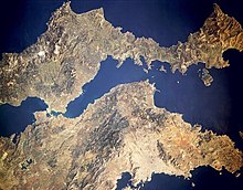
Satellite picture of the South Euboean Gulf, with Euboea on top and the mainland below
The South Euboean Gulf (Greek: Νότιος Ευβοϊκός Κόλπος, Notios Evvoïkos Kolpos) is a gulf in Central Greece, between the island of Euboea and the Greek mainland (Boeotia and Attica). With a total length of approximately 50 km and a width of 10 to 20 km, it stretches nearly diagonally from northwest to southeast, from the Euripus Strait, which connects it to the North Euboean Gulf, to the Petalies Gulf near in the south.
Islands[]
- Petalioi (largest islands:, ), Kavaliani, Stouronisi
Bays by the gulf[]
- , south
- , southwest
- , north
- , northeast
- , northeast
Places by the gulf[]
- , south
- , south
- , southwest
- Nea Palatia, southwest
- Skala Oropou, southwest
- , southwest
- , southwest
- , west
- , west
- , west
- Chalkida, northwest
- Eretria, northwest
- Amarynthos, north
- Aliveri, north
- , northeast

Categories:
- Landforms of Attica
- Euboea
- Gulfs of Greece
- Gulfs of the Aegean Sea
- Landforms of East Attica
- Landforms of Central Greece
- Landforms of Euboea (regional unit)