South Herefordshire
| South Herefordshire | |
|---|---|
 | |
| Area | |
| • 1974 | 223,526 acres (904.58 km2)[1] |
| Population | |
| • 1973[2] | 44,370 |
| • 1992[3] | 52,900 |
| History | |
| • Created | 1974 |
| • Abolished | 1998 |
| • Succeeded by | Herefordshire |
| Status | Non-metropolitan district |
| Government | |
| • HQ | Ross-on-Wye |
| • Motto | Fidelis, Sapiens, Iustus (Honest, thoughtful, just) |
 | |
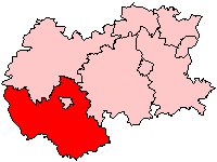
South Herefordshire was one of nine local government districts of the English county of Hereford and Worcester from 1974 to 1998.
South Herefordshire District was formed on 1 April 1974 as part of a general reorganisation of local administration in England and Wales under the Local Government Act 1972. It was formed from part of the administrative county of Herefordshire, and was an amalgamation of four local authorities: Ross-on-Wye urban district, , and .[1][4] The district entirely surrounded the district of Hereford.
Following a review by the Local Government Commission for England, both the County of Hereford and Worcester and the seven districts within it were abolished on 1 April 1998. South Herefordshire was combined with the areas of City of Hereford, most of the District of Leominster, and part of the District of Malvern Hills to form a new unitary County of Herefordshire District: usually referred to simply as Herefordshire.[5]
Parishes[]
The district comprised the following civil parishes:.[6]
References[]
- ^ a b Local government in England and Wales: A Guide to the New System. London: HMSO. 1974. p. 55. ISBN 0-11-750847-0.
- ^ Registrar General's annual estimated figure mid 1973
- ^ OPCS Key Population and Vital Statistics 1992
- ^ The English Non-metropolitan Districts (Definition) Order 1972
- ^ "The Hereford and Worcester (Structural, Boundary and Electoral Changes) Order 1996". Office of Public Sector Information. 1996. Retrieved 13 January 2009.
- ^ "The District of South Herefordshire (Electoral Arrangements) Order 1991". Office of Public Sector Information. 1996. Retrieved 13 January 2009.
Coordinates: 51°59′N 2°42′W / 51.99°N 2.70°W

- History of Herefordshire
- Former non-metropolitan districts of Hereford and Worcester