South Park, Seattle

South Park is a neighborhood in the city of Seattle, in the U.S. state of Washington. It is located just south of Georgetown across the Duwamish River, and just north of the city of Tukwila. Its main thoroughfares are West Marginal Way S. (northwest- and southeast-bound), S. Cloverdale Street (east- and westbound) and 14th Ave. S (north-and-south). South Park connects to Georgetown by two bridges at 1st Ave S. at the northmost end of the neighborhood, and the South Park Bridge at the north end of 14th Ave. South. The South Park Bridge was closed on June 30, 2010 and reconstructed due to safety concerns. The newly constructed bridge reopened to traffic on June 30, 2014.[1]
Surrounded by Seattle's industrial area, South Park's soil and air have been polluted; heavy metals have contaminated the top soil and the nearby Duwamish River has been known for unhealthy levels of toxic chemicals.[2] The property values are lower than elsewhere in Seattle, though some see growth potential in the area.[3][4] The neighborhood is also home to a large Hispanic community with a population that of 4,154 that is roughly 47% Latino, thus giving it the highest concentration of Hispanic residents in the city.[5][better source needed]
Former town[]
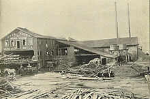
The Town of South Park was incorporated December 9, 1902 and the Town Council held its first meeting on December 23. South Park was served by three mayors in its four-and-one-half years of existence as an independent town: S. J. Bevan (1902–1903), G. C. Lingenfelter (1903–1905), and A. G. Breidenstein (1906–1907).
South Park was plagued by problems in securing adequate city services. Particularly vexing was the inability to obtain a decent water supply. Although the city of Georgetown owned water mains that ran through South Park, it refused to supply water to the latter, starting a bitter court battle over legal rights to the water. In 1905–1906, the town contracted with an independent water company, but in April 1906 the water was found to be contaminated because South Park did not have a sewer system. The Town Council petitioned Seattle to run Cedar River mains to the edge of the town and has had clean water since. The City of Seattle provides sewage services in modern South Park.
In October 1906, the electorate voted 131–59 for annexation to Seattle, but apparently no action was taken beyond the vote. On March 23, 1907, a second vote for annexation was 181–36 in favor and on May 3, 1907, South Park became part of the City of Seattle.[7]
Past and present bridges[]

Prior to the straightening of the Duwamish River for the Duwamish Waterway, South Park was connected to Georgetown by an electric railway that crossed a north-south bridge at 8th Avenue and by an east-west road bridge on County Road a few blocks northeast of that. A bend in the river resulted in the South Park side of that road bridge actually being the east end, with the Georgetown side on the west.[8]
After the Duwamish was straightened, a new bridge was built at 8th Avenue (now 8th Avenue South), and operated from 1914 to 1937.[9]
The present South Park Bridge was a Scherzer Rolling Lift double-leaf bascule bridge, originally built in 1929–31.[10] It is listed on the National Register of Historic Places.[11] It connects 16th Avenue S. in Georgetown to 14th Avenue S. in South Park. It was closed at the end of June 2010 for major reconstruction, including replacement of its bascule leaves. The new bridge opened to the public on June 30, 2014.[12]
Just west of the bridge in South Park is a section of brick road that once led to an earlier bridge on more or less the same site. This brick road—one of the few remaining in Seattle—constitutes the northernmost portion of a road that once led from South Park to Des Moines, Washington; eight blocks south of the Duwamish, today's Des Moines Memorial Drive branches off of 14th Avenue S. leading uphill into unincorporated King County, the area commonly referred to as Boulevard Park.
Cesar Chavez Park[]

The neighborhood is home to Cesar Chavez Park.[13]
References[]
- ^ "South Park Bridge". King County. Retrieved 2015-06-01.
- ^ Eric Pryne, "South Park – 'We're Seattle's Dumping Ground'", Seattle Times, February 24, 1994. Accessed online 3 December 2007.
- ^ A neighborhood on the upswing, Seattle Post-Intelligencer "Webtowns" series (online neighborhood profiles). Accessed online 3 December 2007.
- ^ Seely, Mike (April 12, 2019). "For a Seattle Enclave, Isolation May Be Its Salvation". The New York Times. Retrieved April 13, 2019.
- ^ Lower Duwamish Waterway Site, Seattle, Washington: Hispanic Community Involvement Supplement, Environmental Protection Agency, September 2002, p. 2. Lumps South Park with the neighboring, much less Hispanic, Georgetown and gives a combined South Park/Georgetown population of 4900, which it characterizes as 32% Hispanic. Accessed online 2015-09-22
- ^ David Wilma, Seattle Neighborhoods: South Park – Thumbnail History, HistoryLink essay number 2985, February 16, 2001. Accessed online 3 December 2007.
- ^ Guide to the Town of South Park Records 1902–1907, Northwest Digital Archives, Washington State University. Accessed online 3 December 2007.
- ^ Key map, Sanborn Map Co. Insurance Maps of Seattle, Washington, Volume I, Sanborn Map Co., New York, (1904). The relevant portion of the map can be seen at Commons:File:Seattle - Sanborn 1904 - Georgetown & South Park map - 1904.jpg.
- ^ Informational sign at Eighth Avenue South/South Park Public Shoreline Access, Port of Seattle. Consulted 2009-04-26.
- ^ King County 2005 Bridge Report Archived 2006-10-05 at the Wayback Machine, p. 24. Accessed online 2009-04-28.
- ^ SOUTH PARK BRIDGE PROJECT Draft Environmental Impact Statement and Section 4(f) Evaluation EXECUTIVE SUMMARY Archived 2010-08-05 at the Wayback Machine, U.S. Department of Transportation Federal Highway Administration, Washington State Department of Transportation, and King County Department of Transportation, September 2005, p. S-1 (p. 9 of PDF). Accessed online 2009-04-28.
- ^ Executive Constantine announces new South Park Bridge to open on June 30, King County Executive, June 4, 2014, retrieved 2014-06-05
- ^ "Cesar Chavez Park". www.seattle.gov. Retrieved 2019-03-31.
External links[]
| Wikimedia Commons has media related to South Park, Seattle, Washington. |
- "Guide to the Town of South Park Records 1902–1907". Seattle Municipal Archives.
- David Wilma (2001-02-16). "Seattle Neighborhoods: South Park – Thumbnail History". HistoryLink.
essay number 2985
- Kathy Mulady (2006-09-16). "Budget boosts South Park". Seattle Post-Intelligencer.
| show Authority control |
|---|
Coordinates: 47°31′49″N 122°19′26″W / 47.53028°N 122.32389°W

- Former municipalities in Washington (state)
- Neighborhoods in Seattle