South West Khasi Hills district
South West Khasi Hills district | |
|---|---|
District | |
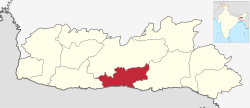 Location of South West Khasi Hills district in Meghalaya | |
| Coordinates (Mawkyrwat): 25°18′N 91°12′E / 25.3°N 91.2°ECoordinates: 25°18′N 91°12′E / 25.3°N 91.2°E | |
| Country | India |
| State | Meghalaya |
| Headquarters | Mawkyrwat |
| Area | |
| • Total | 1,341 km2 (518 sq mi) |
| Population (2011) | |
| • Total | 110,152 |
| • Density | 82/km2 (210/sq mi) |
| Demographics | |
| • Literacy | 76.84 |
| Time zone | UTC+05:30 (IST) |
| Website | southwestkhasihills |

South West Khasi Hills is an administrative district in the state of Meghalaya in India.
History[]
The South West Khasi Hills district was carved out of the West Khasi Hills district on 3 August 2012.[1]
Geography[]
The district headquarters is located at Mawkyrwat. The district occupies an area of 1,341 km². The district is compose all the villages of two Community & Rural Development Blocks viz. and Mawkyrwat are Community & Rural Development Block, including 18 (Eighteen) Villages under Warsan Lyngdoh Gram Sevak Circle of Nongstoin in Community & Rural Development Block.
Administrative divisions[]
South West Khasi Hills district is divided into two blocks
| Name | Headquarters | Population | Location |
| Mawkyrwat | Mawkyrwat |  | |
| Ranikor | Ranikor |  |
References[]
- ^ Official circular regarding Mawkyrwat Archived 2013-11-05 at the Wayback Machine
External links[]
Places adjacent to South West Khasi Hills district | ||||||||||||||||
|---|---|---|---|---|---|---|---|---|---|---|---|---|---|---|---|---|
| ||||||||||||||||
| State symbols | |
|---|---|
| Topics | |
| Administration |
|
| Divisions |
|
| Districts | |
| Municipalities | |
| |
Categories:
- South West Khasi Hills district
- Districts of Meghalaya
- 2012 establishments in Meghalaya
- Autonomous regions of India
- Meghalaya geography stubs