Soy Street
This article needs additional citations for verification. (January 2014) |
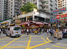 Soy Street in July 2012 | |||
| Native name | 豉油街 (Yue Chinese) | ||
|---|---|---|---|
| Location | Kowloon, Hong Kong | ||
| Coordinates | 22°18′58″N 114°10′02″E / 22.316096°N 114.167243°ECoordinates: 22°18′58″N 114°10′02″E / 22.316096°N 114.167243°E | ||
| West end | Tak Cheong St | ||
| East end | Yim Po Fong St | ||

| Soy Street | |||||||||||||
|---|---|---|---|---|---|---|---|---|---|---|---|---|---|
| Chinese | 豉油街 | ||||||||||||
| Cantonese Yale | sih yàuh gāai | ||||||||||||
| |||||||||||||

Temporary pedestrian zone in July 2012.
Soy Street (Chinese: 豉油街) is a street in Mong Kok, Kowloon, Hong Kong. It starts from Tak Cheong Street in the west, crosses several major streets including Nathan Road, and ends near Waterloo Road.
The section between Nathan Road and Sai Yeung Choi Street South is for pedestrians only. The section between Nathan Road and Fa Yuen Street becomes crowded with people during the holiday season and at night.
History[]
The name Soy Street comes from a soya bean factory located in the area long ago.[1] In June 2004, pottery from the Eastern Han Dynasty (25–220 AD) and Jin Dynasty (266–420 AD) were discovered at a construction site at the junction of Soy Street and Tung Choi Street.[2][3]
See also[]
References[]
- ^ Jason Wordie (2007). Streets: Exploring Kowloon. Hong Kong University Press. ISBN 978-962-209-813-8. p. 57
- ^ "Relics Found at the Works Site in Mongkok"
- ^ "Archaeological monitoring by the AMO at a drainage site in Mongkok finished today "
External links[]
 Media related to Soy Street at Wikimedia Commons
This Hong Kong road article is a stub. You can help Wikipedia by . |
Categories:
- Mong Kok
- Roads in Hong Kong
- Hong Kong road stubs