Spaarnwoude
Coordinates: 52°24′N 4°42′E / 52.400°N 4.700°E

Spaarnwoude | |
|---|---|
 Spaarnwoude village | |
 Seal | |
 | |
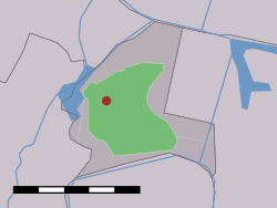 The village (dark red) and the statistical district (light green) of Spaarnwoude in the former municipality of Haarlemmerliede en Spaarnwoude. | |
| Country | Netherlands |
| Province | North Holland |
| Municipality | Haarlemmermeer |
Spaarnwoude is a hamlet in the Dutch province of North Holland. It is a part of the municipality of Haarlemmermeer and lies about 5 km (3.1 mi) northeast of Haarlem.
The statistical area "Spaarnwoude", which also can include the surrounding countryside, has a population of around 200.[1]
North of Spaarnwoude lies the Spaarnwoude recreation area, which is located in the municipalities of Velsen and Haarlemmermeer.
There is a railway station, Haarlem Spaarnwoude, which lies southwest of the village. An IKEA shop is nearby, on the north side. To the east of IKEA is the Veerplas.
Spaarnwoude was a separate municipality until 1857, when it merged with Haarlemmerliede.[2] The resulting municipality of Haarlemmerliede en Spaarnwoude was later merged with Haarlemmermeer, in 2019.[3]

See also[]
References[]
- ^ Statistics Netherlands (CBS), Statline: Kerncijfers wijken en buurten 2003-2005. As of 1 January 2005.
- ^ Ad van der Meer and Onno Boonstra, Repertorium van Nederlandse gemeenten, KNAW, 2011.
- ^ "Gemeentelijke indeling op 1 januari 2019" (in Dutch). CBS. Retrieved 1 January 2019.
External links[]
- Map of Spaarnwoude.
- J. Kuyper, Gemeente Atlas van Nederland, 1865-1870, "Spaarnwoude". Map of the former municipality, around 1868.
| hide Authority control | |
|---|---|
| General |
|
| National libraries | |
This North Holland location article is a stub. You can help Wikipedia by . |
- Populated places in North Holland
- Haarlemmermeer
- North Holland geography stubs