Spangmik
Spangmik | |
|---|---|
 Spangmik Location in Ladakh | |
| Coordinates: 33°54′25.9″N 78°27′26.28″E / 33.907194°N 78.4573000°ECoordinates: 33°54′25.9″N 78°27′26.28″E / 33.907194°N 78.4573000°E | |
| Country | |
| Union Territory | Ladakh |
| Territory | Ladakh |
| District | Leh district |


Spangmik is a settlement near Lukung on the south India-China border in the Leh District, Ladakh.
Location[]
Spangmik is situated 156 kilometers east of Leh, on the southern banks of Pangong Tso. It located on "a narrow stretch of land between the Chang Chenmo mountains and the lake".[2]
The village is very close to the Line of Actual Control thats why tourists are allowed till this village.[3] Further journey is prevented by an Indian Army check post. [2]
In 2019, Ladakh Autonomous Hill Development Council, Leh dismantled illegal tents and other construction on state-owned land in Spangmik village.[4] But, the villagers have sought permission to re-erect these tents camps on the banks of the lake, and blamed the LAHDC for "pushing locals away from their land and unwittingly encouraging the Chinese to occupy it".[5]
Gallery[]
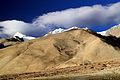
Peaks around the Pangong Tso at Spangmik (September 2013)
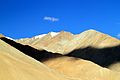
Peaks around the Pangong Tso at Spangmik (September 2013)

Pangong Tso on a bright sunny day, View from Spangmik (August 2009)
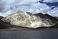
View of Pangong Tso from Spangmik (July 2004)


References[]
- ^ "Spangmik". Spangmik on Google Maps.
- ^ a b Sarjolta, Divya (2020-09-25). "Spangmik Village Near Pangong Lake: Explore the Beauty". BUDGET WAYFARERS. Retrieved 2021-11-02.
- ^ "India-China conflict in Ladakh: What is the importance of Pangong Tso lake?". The Indian Express. 2020-09-01. Retrieved 2021-11-02.
- ^ "All izz not well in Ladakh". @businessline. Retrieved 2021-11-03.
- ^ Rashid, Hakeem Irfan. "Locals near Pangong Tso Lake seek nod to re-erect tourist camps". The Economic Times. Retrieved 2021-11-03.
This Ladakh, India location article is a stub. You can help Wikipedia by . |
- Villages in Leh district
- Villages in Durbuk tehsil
- Ladakh stubs
- India geography stubs