Spišské Podhradie
Spišské Podhradie | |
|---|---|
Town | |
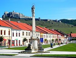 View on Spišské Podhradie from Spiš Castle | |
 Coat of arms | |
 Spišské Podhradie Location of Spišské Podhradie in Slovakia | |
| Coordinates: 49°00′00″N 20°45′06″E / 49.00000°N 20.75167°ECoordinates: 49°00′00″N 20°45′06″E / 49.00000°N 20.75167°E | |
| Country | Slovakia |
| Region | Prešov |
| District | Levoča |
| First mentioned | 1249 |
| Government | |
| • Mayor | MVDr. Michal Kapusta |
| Area | |
| • Total | 24.94 km2 (9.63 sq mi) |
| Elevation | 430 m (1,410 ft) |
| Population (2018-12-31[1]) | |
| • Total | 4,013 |
| • Density | 160/km2 (420/sq mi) |
| Postal code | 05304 |
| Area code(s) | +421-53 |
| Car plate | LE |
| Website | www.spisskepodhradie.sk |

Spišské Podhradie is a town in Spiš in the Prešov Region of Slovakia. Its population is around 4,000.
Spišské Podhradie is situated at the foot of the hill of Spiš Castle. It had a Zipser German settlement, with its own church and priest, in 1174. Just above, and adjacent to, the town is the ecclesiastical settlement of Spišská Kapitula (hence an old German name Kirchdorf, meaning "church town"). The town contains a number of Renaissance merchants' houses. It also has one of the few remaining synagogue buildings (now disused) in the region.
Twin towns — sister cities[]
Spišské Podhradie is twinned with:
 Głogów Małopolski, Poland
 Pinetop-Lakeside, Arizona, United States
- Show Low, Arizona, United States
 Vrbové, Slovakia
Pictures[]

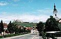
Road in Spišská Kapitula with Spiš Castle above

Synagogue at Spišské Podhradie
Town center and Spiš Castle above


References[]
- ^ "Population and migration". Statistical Office of the Slovak Republic. Retrieved 2019-04-16.
External links[]
| show Municipalities of Levoča District |
|---|
| show Authority control |
|---|
This Prešov Region geography article is a stub. You can help Wikipedia by . |
- Cities and towns in Slovakia
- Spiš
- World Heritage Sites in Slovakia
- Prešov Region geography stubs