Spuistraat
It has been suggested that Nieuwezijds Achterburgwal be merged into this article. (Discuss) Proposed since September 2021. |
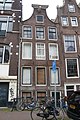
 Bakery D.C. Stähle on Spuistraat 274, a Jugendstil design from 1898 by Gerrit van Arkel. On the left, the 1924 Gerzon building | |||
| Location | Amsterdam, Centrum | ||
|---|---|---|---|
| Postal code | 1012 | ||
| Coordinates | 52°22′23″N 4°53′22″E / 52.373056°N 4.889444°ECoordinates: 52°22′23″N 4°53′22″E / 52.373056°N 4.889444°E | ||
| From | Spui | ||
| To | Hekelveld | ||
| Construction | |||
| Inauguration | Named in 1867 | ||


The Spuistraat in downtown Amsterdam connects the to the Spui. It runs roughly north to south, parallel to the Singel and the Nieuwezijds Voorburgwal. At the Royal Palace of Amsterdam, the Spuistraat crosses the Raadhuisstraat and . Originally the Spuistraat was a canal, the Nieuwezijds Achterburgwal. The canal was filled in in 1867, and the street renamed then.
History[]
The Nieuwezijds Achterburgwal was part of the medieval city and was once the western limit of the city of Amsterdam.
Until about the 14th century, the river Amstel divided the city in two roughly equal parts--the with the Oude Kerk and the with the Nieuwe Kerk. To protect the city, a canal was dug on each side, with a city wall behind it made of dirt with a wooden palisade. When new fortifications were built around 1385, the existing ones became "Voorburgwal" ("voor" meaning "in front"), and the new ones "Achterburgwal" ("achter" meaning "behind"), on both the old side and the new side. This created the Oudezijds Voorburgwal, Oudezijds Achterburgwal, Nieuwezijds Voorburgwal, and Nieuwezijds Achterburgwal, dug in 1380.
The Nieuwezijds Achterburgwal had warehouses and stables that belonged to the larger houses on the Nieuwezijds Voorburgwal.[1] In 1867 the Nieuwezijds Achterburgwal and part of the nearby were filled in, and the former canal was called the Spuistraat. On the south side, the street ends at the Spui.[2]
Among the many alleys and streets connecting the Nieuwezijds Voorburgwal and Achterburgwal was the Stilsteeg; it and Korte Gasthuismolensteed were widened in 1875 to create the .[3] Around 1895 the Huiszittensteeg and the Korte Huiszittensteeg were widened to create the Raadhuisstraat
The first horsecar ran through the Spuistraat in 1877, from the Dam Square to the Leidseplein. It was replaced in 1903 by an electric streetcar, line 2, which ran to the Leidseplein by way of the Nieuwezijds Voorburgwal and Spui; in 1904 line 2 was added. The streetcar Amsterdam - Haarlem - Zandvoort ran from 1904 to 1957 from the Raadhuisstraat through the southern end of the street, and from 1914 to 1957 it ended on the Spuistraat. From 1961 to 1974 a number of bus lines of the Gemeentelijk Vervoerbedrijf ended on the Spuistraat. These days, the street is part of the city loop that guides traffic through downtown. Attempts by locals to have that loop shifted to the (wider) Nieuwezijds Voorburgwal have failed.[4]
Notable buildings[]
- Spuistraat 12: Dominicus church, designed by Pierre Cuypers, built in 1886 on Spuistraat 12 / Korte Korsjespoortsteeg / Teerketelsteeg. Between 1845 and 1884 this was the location of the Roman Catholic clandestine church, designed by R. van Zoelen, the Dominicus Schuilkerk. Before that, there was another clandestine church, the "Stadhuys van Hoorn", built by the Dominican order in 1624.[5][6]
- Spuistraat 111-123: the back of the , built in the style of the Amsterdamse School. The front of the building is in the style of the neorenaissance, on the Nieuwezijds Voorburgwal 162-170.
- Spuistraat 137-139, corner of Raadhuisstraat, is the backside of the Magna Plaza department store, formerly the main post office, built 1895-1899, designed by .
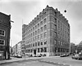
- Spuistraat 175: one side of the monumental building, behind the Royal Palace on the Dam, built around 1924 by royal architect as the Rijkskantoorgebouw voor het Geld- en Telefoonbedrijf. It was turned into a supermarket in 2000, with offices on the upper floors.[7]
- Spuistraat 172: corner of Paleisstra, a bank building designed in 1932 by for the N.V. Kasvereeniging.
- Spuistraat 210: Bungehuis, built in the 1930s by and W.J. Klok, later used by the University of Amsterdam's Department of Humanities
- Spuistraat 216: the squat Vrankrijk. Opposite are the Tabakspanden, which had been mostly squatted from 1983 onwards. Slated for renovation (and luxury apartments), the squats were evicted in 2015.[8]
- Spuistraat 134: P. C. Hoofthuis, built by Aldo van Eyck and in 1984, also used by the University of Amsterdam's Department of Humanities.
- Spuistraat 274: bakery of D. C. Stähle, on the corner with the , built in 1898 after a Jugendstil-design by Gerrit van Arkel.
- Spuistraat 297: Gerzon building, built in 1924 by A. Moen for the Gerzon Bros, a fashion retailer, now a hotel.
Gallery[]
Rijksmonument Spuistraat 39

Rijksmonument Spuistraat 303
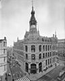
Former main post office, now Magna Plaza, corner of Spuistraat and Raadhuisstraat; March 1994

Spuistraat 175, Rijkskantoorgebouw voor het Geld- en Telefoonbedrijf; augustus 1983
Spuistraat 220, front of Bungehuis, Department of Letters; October 1984

Spuistraat 85-87; April 1976


See also[]
References[]
- ^ De restauratie van Spuistraat 233, Amsterdam, Vastgoed belang, augustus 1998
- ^ Overzicht dempingen vanaf de 19de eeuw, Vrienden van de Amsterdamse Binnenstad
- ^ Lesger, Clé (2013). Het winkellandschap van Amsterdam: Stedelijke structuur en winkelbedrijf in de vroegmoderne en moderne tijd, 1550-2000 (in Dutch). Verloren. p. 232. ISBN 9789087043735.
- ^ Bestuur Centrum A'dam houdt vast aan herprofilering Spuistraat
- ^ Dominicus Kerk, amsterdam.nl
- ^ Stadhuis van Hoorn te Amsterdam, gendijk.nl
- ^ Monumentenvoorinformatie, Gemeente Amsterdam, Bureau Monumenten & Archeologie
- ^ "Eviction of Amsterdam squatters turns violent". Al Jazeera. 26 March 2015. Retrieved 3 August 2019.
| Wikimedia Commons has media related to Spuistraat, Amsterdam. |
- Streets in Amsterdam